|
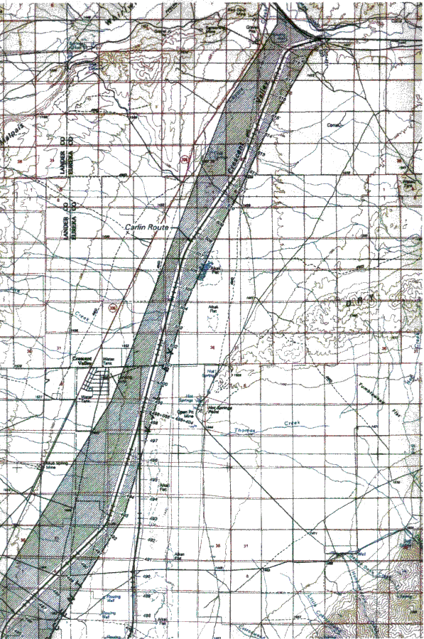
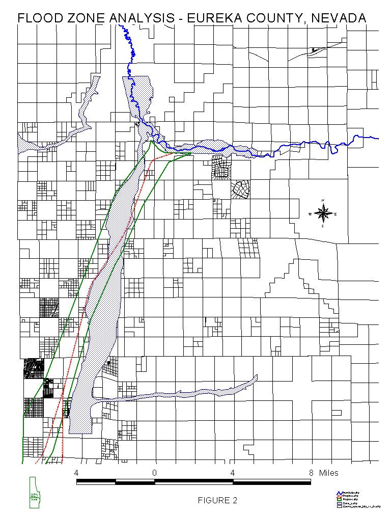
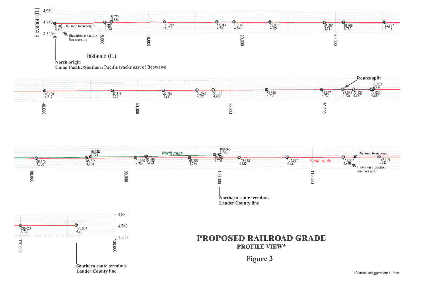
Part 2: DESCRIPTION OF PROPOSED ACTION Transportation scenarios Scenarios generally. For the transportation of spent nuclear fuel (SNF) and high-level radioactive waste (HLW) to the proposed geologic repository at Yucca Mountain, the United States Department of Energy (DOE) has identified five potential rail corridors, five potential heavy-haul truck routes, and three potential intermodal transfer locations in Nevada. The DOE has also identified three basic transportation scenarios: mostly rail, mostly legal-weight truck, and heavy-haul truck (USDOE, 1999a). Actual transportation modal mix. The DOE has not yet said what the actual modal mix would be for shipments of SNF and HLW to the proposed repository. The actual mix would probably involve different truck/rail splits than described in the three DOE scenarios, and could involve different sizes of rail and truck casks (USDOE 1999a). The Nevada Agency for Nuclear Projects believes that the most probable modal mix, if a new rail spur were constructed and operated, is 26,400 truck shipments and 14,100 rail shipments over 38 years. If no new rail spur were constructed, there would be 96,000 truck shipments (Halstead 2001). Note, however, that all scenarios require either rail or heavy-haul access to the proposed repository, for naval SNF shipments if not others. At the present time, there is no rail access to the proposed repository (USDOE, 1999a). Rail transportation would have the highest construction cost and is the basis for the DOE's reference program design. Full-scale heavy-haul truck transportation would involve lower construction costs than rail transportation, but higher operations and maintenance costs. Total life-cycle costs would be about the same (Bechtel SAIC, 2001). Mostly rail scenario. The mostly-rail scenario involves construction of a spur rail line to Yucca Mountain, which would handle most of the shipments of SNF and HLW. About 20 percent of commercial SNF shipments would, however, take place by legal-weight truck. There would be 450 annual rail shipments on the spur line, plus 110 annual truck shipments. Over a possible 38-year period of shipments and disposal, there would be about 20,000 total rail shipments, plus 3,700 truck shipments from commercial reactor sites that cannot load rail cars (USDOE, 1999a). Mostly legal-weight truck scenario. In this scenario, most shipments of SNF and HLW would travel directly to the proposed repository by legal-weight truck. Federal regulations require the use of preferred routes, including the interstate system, beltways, and bypasses. The proposed truck routes in Nevada would include I-15 and US 95. The DOE assumes that a complete beltway around the Las Vegas metropolitan area will be operational by 2010. States and tribes may designate alternate routes, also in accordance with federal regulations, after considering public risk, consulting with local governments, and consulting with other affected states (USDOE 1999a). Alternate truck routes considered to date by Nevada’s Department of Transportation do not pass through Eureka County, but would carry SNF and HLW entering Nevada from the east through Elko County and White Pine County toward Yucca Mountain (Halstead, 2001). However, since all scenarios involve some transport by legal-weight truck, since no specific alternate route has yet been designated, and since weather or other operational variables could force the use of other additional routes, I-80, U.S. 50, and Nevada 278 in Eureka County could be used periodically or regularly to transport SNF and HLW to Yucca Mountain. The mostly legal-weight truck scenario includes some overweight, over-dimensional (but not heavy-haul) truck shipments with a gross vehicle weight of 40 to 57.5 tons and some rail shipments. There would be 2,100 average annual truck shipments, plus 13 annual rail shipments of naval SNF from Idaho to Nevada, which would proceed to the proposed repository by heavy-haul truck. (USDOE, 1999a) Heavy-haul truck scenario. This scenario involves the construction in Nevada of highway improvements and an intermodal station for the transfer of rail casks to heavy-haul trucks, and for the transfer of empty rail casks from heavy-haul trucks back to rail cars. All of the sites and routes the DOE has identified are in Clark, Nye, Lincoln, and Esmeralda Counties. (USDOE, 1999a) According to the Bechtel SAIC report (2001), difficulties in obtaining permits from Nevada's Department of Transportation for each heavy-haul truck shipment could significantly limit the rate of waste shipment by this mode. The report says the use of heavy-haul trucks on public highways could, therefore, be untenable for the proposed rate of shipments. "Scenarios that include this alternative are assumed to incur uncertainties in acceptance by the public and regulatory agencies in addition to those associated with the mostly rail alternative," the report says. Carlin rail corridor, specifically. One of the five potential rail corridors the DOE has identified for transporting SNF and HLW to the proposed repository is the Carlin route, which passes through Eureka County. (See the corridor map, Figure 1.) The entire route is 317 miles (520 km) in length, and the DOE has classified the route as 100 percent rural. The Carlin rail corridor originates at the Union Pacific tracks near Beowawe, and converges with another potential corridor, the Caliente corridor, south of Tonopah (USDOE, 1999a). The corridor passes through the Crescent Valley, Grass Valley, and Big Smokey Valley. It crosses U.S. 50 east of the town of Austin, crosses U.S. 95 between Tonopah and Goldfield, and generally follows U.S. 95 and the western boundary of the Nellis Air Force range to Yucca Mountain (Halstead, 2001). The DOE has identified 10 possible alignment variations for the corridor, including a variation in Crescent Valley near the Cortez mine (USDOE, 1999a). As discussed later, the DOE may share the use of the rail corridor with mines and other users. Figure 1 Map of corridor for proposed Carlin rail line in Eureka County Figure 2 Area of 100-year flood, mapped by FEMA Corridor maps prepared by DOE contractors designate the 13-mile (22-km) portion of the corridor from Beowawe to the divergence of the Crescent Valley alternative as Segment 5M, and the 15-mile (24.2-km) portion between the start and end of the Crescent Valley alternative as Segment 5L (Moore, 2001a). The proposed Carlin corridor crosses the area of the 100-year flood (as mapped by the Federal Emergency Management Agency in 1998, see Figure 2), or runs immediately adjacent to that area, for at least eight miles between Beowawe and the Town of Crescent Valley. The proposed location of the connections to the UPRR tracks at Beowawe may or may not be in the area of the 100-year flood, but portions of the existing tracks along the Humboldt River are. The estimated cost of constructing the
Carlin route is about $1 billion; the estimated cost of the portion within
Eureka County is $50 to $60 million.
These estimates include the roadbed and track only. The estimated cost breakdown for the portion
within Eureka County is: labor (16 percent), material (51 percent), equipment
(14 percent), and right-of-way acquisition, engineering, and miscellaneous (20
percent) (Moore, 2001a).
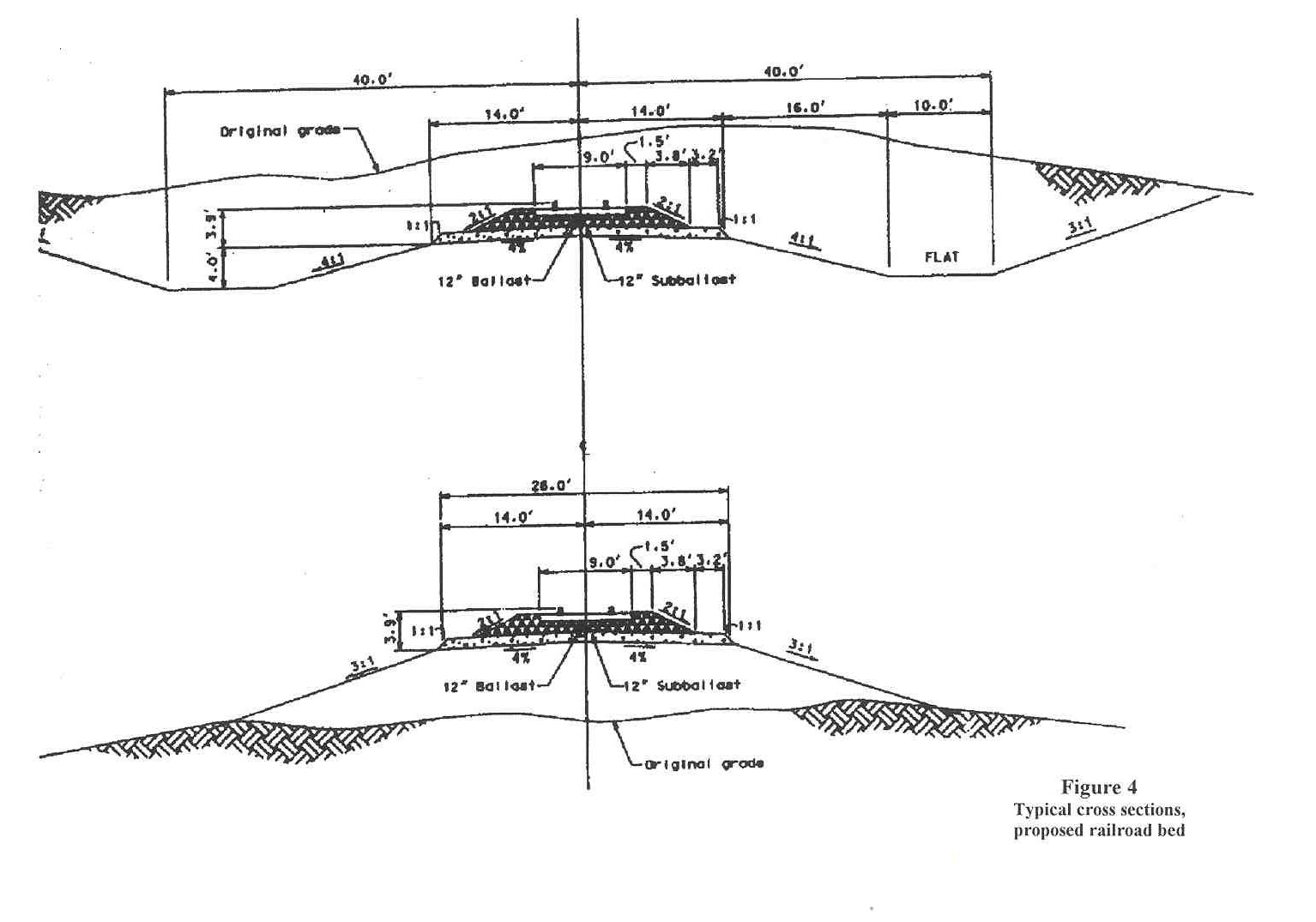
Proposed schedule If the shipments of SNF and HLW include the so-called Modules 1 or 2 described in the DEIS for the proposed repository, there would be at least 38 years of shipments, ending in the year 2047. (For purposes of this impact assessment report, Eureka County has selected 38 years as the minimum time period for analysis.) The DOE’s Office of Civilian Radioactive Waste Management would identify the preliminary route approximately four years before shipments begin. After route selection, engineering studies, design, land acquisition, and installation of wells along the route, the DOE says actual construction would take about 2.5 years (USDOE, 1999a). However, the State of Nevada believes that construction could require five to seven years, and that environmental reviews and approvals, land acquisition, and consideration of Native American rights could delay construction an additional five to ten years (Halstead, 2001). Construction of the proposed repository facilities for handling SNF and HLW would begin after receipt of construction authorization from the Nuclear Regulatory Commission (NRC). The DOE assumes that construction will begin in 2005, and that the initial construction phase will last five years, from 2005 to 2010 (USDOE, 1999a). Repository operations would begin after the DOE receives a license from the NRC. Although the DOE has recently discussed an accelerated schedule, the DEIS assumes receipt and emplacement of SNF and HLW will begin in 2010. At the end of the period during which the DOE transports SNF and HLW, the DOE would remove the transportation facilities or use them for other purposes. The DOE assumes that closure of the proposed repository (as opposed to the open, monitored condition) will begin 100 years after the start of emplacement, but considers a range of 50 to 300 years. Repository closure would take six to 15 years (USDOE, 1999a). Packaging and vehicles Legal-weight trucks. Legal-weight trucks used to transport SNF and HLW to the proposed repository would weigh 25 tons (22,750 kg) when loaded. A legal-weight truck is defined as one with a gross vehicle weight of less than 40 tons (36,400 kg), which is the loaded weight limit for commercial vehicles operated on public highways without special state permits. The dimensions, axle spacing, and axle loads would comply with federal and state requirements (USDOE, 1999a). The DOE has provided a drawing of a legal-weight truck in the DEIS at page 2-39. The drawing depicts a shipping cask, 20 to 23 feet in length, on a tractor/trailer combination about 70 feet long. Heavy-haul trucks. Heavy-haul trucks used to transport SNF and HLW would be overweight, over-dimension vehicles, which must have state permits to use public highways. They would move SNF and HLW shipping casks designed for transport by rail car (USDOE, 1999a). Rail cars. The DOE has provided a drawing of a rail car that would be used to transport SNF and HLW, at page 2-39 of the DEIS (1999a). The drawing depicts a rail cask, 20 to 23 feet in length, on a rail car of 60 feet. Shipping containers. The large shipping containers that would be loaded on rail cars, legal-weight trucks, and heavy-haul trucks are called “casks.” Smaller containers loaded inside the casks are called “canisters.” There are numerous possible shipping cask configurations. A rail cask could contain: (1) six to twelve metric tons of heavy metal (MTHM) of commercial SNF, in the form of up to 36 SNF assemblies, (2) five canisters of HLW, (3) four to nine canisters of DOE SNF, except naval SNF, or (4) disposable canisters of naval SNF. Each legal-weight truck cask could contain: (1) 1.8 MTHM of commercial SNF, in the form of up to four SNF assemblies or (2) one canister of DOE SNF (except naval SNF) or HLW. Naval SNF would not be shipped by legal-weight truck (USDOE, 1999a). Disposal containers. The containers that DOE would use to emplace SNF and HLW underground at the proposed repository weigh 36 tons (33,000 kg), with a ¾-ton (700-kg) lid. They would be delivered to the proposed repository by rail (7,900 deliveries in 38 years), with SNF and HLW or on separate supply trains. Or, if rail service is not available, the disposal containers would be shipped on overweight trucks, in 15,800 separate shipments (USDOE, 1999a). Rail spur construction Corridor and site. To implement the Nevada rail scenario, DOE would obtain a corridor right-of-way 1300 feet (400 meters) wide to construct a rail line and access road. According to the DOE, the actual construction width would be about 200 feet (60 meters). Less than 15 percent of the land in the corridor would be disturbed, as well as less than a square mile outside the corridor, which would be disturbed for roads, camps, and other purposes. Vegetation would be cleared from the 200-foot construction corridor and from well sites, borrow areas, and construction camps, and buried in disposal areas for excavated materials (USDOE 1999a). The exact location and alignment of the branch rail line would be determined after consideration of: (1) the minimum impact to flood plains, wetlands, private land, capital improvements, areas containing cultural resources, and other environmentally sensitive areas, (2) the minimum size and number of easements, (3) consultation with persons controlling the land regarding the location of staging areas and construction camps, and (4) the need to reclaim disturbed lands outside the right-of-way after construction (USDOE 1999a). The total length of the Carlin rail corridor in Eureka County (from the vicinity of Beowawe to the vicinity of the town of Crescent Valley) is about 18.25 miles. The DOE proposes two wye (or "Y") turnouts for connection to the existing eastbound and westbound UP tracks, one to two miles east of Beowawe in section 9, T31N, R49E. Wye turnouts from both sets of tracks would allow eastbound and westbound trains access to the Carlin rail spur without having to back trains. The DOE selected Beowawe because there is sufficient room to construct the wye connections. Either a grade-separated or at-grade crossover of the existing southern tracks would be required (Moore, 2001a). Additional terminal facilities would be constructed at the location of the wye, east of Beowawe. These facilities would require a significant land area, the size and location of which are not yet specified. They would probably include: interchange tracks; turning tracks; emergency material storage tracks (i.e., rail cars loaded with ballast, rail panels, and other supplies), chain link fencing, a HiRail pad, an emergency station, garage and storage building, crew station and office, and locomotive service facility (Moore, 2001b). The facilities could also include an operations center; maintenance headquarters; automotive vehicle maintenance facility; dormitory; fueling station; and rail car repair shop (Moore, 2001a). The DOE plans one grade-separated road crossing in Eureka County, for the intersection of the proposed rail line with the Dean/Dann/Spa Road, County Road M-115. The grade separation would be just east of the Town of Crescent Valley. The DOE also plans one signaled at-grade road crossing at an unspecified location; the remaining crossings would be unsignaled, at grade (Moore, 2001b). Design. Design criteria for the Carlin rail spur include a requirement that the 100-year flood would not inundate the rails at channels fed by sizable drainage areas. The rail line would be designed and built in accordance with Federal Railroad Administration (FRA) safety standards (USDOE, 1999a). The maximum preferred grade would be 1.5 percent, based on the requirements for moving high axle-load cars downgrade. If 1.5 percent is not feasible, the maximum grade would be 2.2 percent, and less than 2.5 percent at all locations. (See proposed rail line profile, Figure 3.) The maximum allowable curvature would be 8 degrees. Where feasible, the curvature would be less than or equal to 2 degrees. Moore says that the minimum right-of-way width is 200 feet (100 feet on each side of the centerline), and wider in cut/fill areas. The right-of-way would be fenced if fencing is required by the landowner or land management agency (Moore, 2001a). Typical cross sections for a railroad bed are shown in Figure 4. The actual width would be dependant on the terrain. For a typical fill cross section, the width of the area covered by fill would be approximately 50 feet. The width of cut cross sections would vary, but would probably average about 100 feet. An access road will parallel the tracks for service and maintenance (Moore, 2001a). Track would be 115-pound continuous welded rail. Ties would be either timber or preformed concrete ties (Moore, 2001a). Actual construction. The overall construction sequence for the Carlin rail spur would consist of: (1) development of support areas and access roads, (2) construction of major structures, (3) construction of the rail bed, simultaneously at multiple locations, (4) installation of culverts and underpasses, if any, (5) replacement of topsoil and installation of silt controls, (6) laying ties and rails on the subgrade, (7) placement of ballast with special rail-mounted equipment, and (8) installation of signal and communications systems. Engineering, design, and land acquisition would precede this construction sequence (Moore, 2001a) as would development of water wells along the corridor. Construction camps would be closed after construction is finished in an area (USDOE, 1999a). The DOE has not identified the numbers of support areas and rail bed construction initiation points. Their numbers and locations would depend on the final route; the length of the route; the schedule; the number of major structures; and the location of existing roads. The DOE estimates that five construction camps would be placed at about equal distances to provide construction support and temporary housing. (Note that five equally spaced camps in a 317-mile distance means that camps would be about 60 miles apart.) The proposed location for one construction camp is located in Lander County, just east of the Lander-Eureka county line. However, such a camp could be moved to Eureka County, closer to developed areas. Materials and equipment would be delivered to initiation points and work camps by truck (Moore, 2001a, 2001b; USDOE, 1999a). A project of this size would require significant lay-down areas to store construction materials. Since much material would probably be delivered by train, the logical location for one lay-down area is near Beowawe (Moore, 2001b). Rail bed construction would use conventional earth-moving
equipment: bulldozers, scrapers, and dump trucks. After vegetation is cleared, topsoil would be removed and
stockpiled. A temporary access road
would probably be built along and within the right-of-way (Moore, 2001a) and a permanent service road would be built
and maintained along the rail line (USDOE, 1999a). The subgrade would be a stable, raised bed about 28 feet wide,
composed of gravel and soils. Subgrade
material would be placed and compacted, and water would be applied to achieve
dust control and compaction.
Sub-ballast material (granular and well-graded, similar to highway base)
would then be placed and compacted to a depth of 6 to 12 inches. The DOE has not identified the source of the
sub-ballast; it is usually obtained from local gravel pits (Moore, 2001a). Figure 3 Profile of proposed Carlin rail line in Eureka County Figure 4 Typical cross sections, proposed railroad bed After support areas and access roads are in place, bridges across major drainages and highway grade separations would be constructed. These activities involve placement of pre-cast concrete structures, following site preparation and pouring of footings. The DOE has not specified the location of the pre-cast plant and staging yard (Moore, 2001a). During and after construction of the rail bed, local road underpasses, livestock underpasses, and culverts would be installed. Local road underpasses are typically 14-foot square box culverts; livestock underpasses are usually eight-foot diameter steel culverts (Moore, 2001a). At-grade crossings would also be installed and existing utility lines would be rerouted as required (USDOE, 1999a). During construction, trucks would spray water on graded areas for dust control and soil compaction. Water would be shipped from other locations or obtained from wells along the route. The DOE says the Carlin route would require 660 acre-feet (28.7 million cubic feet) of water from 67 wells, that groundwater withdrawals during construction would require temporary permits from the State of Nevada, and that the DOE may lease temporary water rights along the corridor. If groundwater cannot be withdrawn along the route, it would be transported to construction sites by truck (USDOE, 1999a). Note that the water would be delivered by truck in any event; the variable is the distance the truck must travel from the water source. Note also that the DOE’s estimates of the amount of water required do not include water for making concrete poured on site. The next construction step would be placing ties and continuous welded rail on top of the subgrade. The rail would be produced at a facility near existing rail lines, in Nevada or elsewhere. Crews would distribute ties along the rail bed by truck and deliver rail sections on special rail cars. Beginning at the wye connection to the main rail lines, rail sections would be placed, welded, and fastened to the ties. Trains traveling on newly laid sections of track would deliver the next rail sections (Moore, 2001a). Once the continuous rail is placed and fastened, crews would deliver ballast in bottom-dump rail cars and put it in place using specially designed rail-mounted equipment. Ballast would be compacted in place to a minimum depth of 8 to 12 inches, using tamping equipment, and additional ballast would be placed on curves (Moore, 2001a). After the rail bed is complete, final grading of slopes would take place, rock-fall protection devices would be installed, and topsoil would be replaced on disturbed areas, which would be seeded and mulched. Silt fences, plastic netting, and other erosion control devices would be installed. Signals, monitoring equipment, and communications equipment would be installed. The DOE (1999a) says that fences would be installed along the rail line if requested by such agencies as the BLM and the U.S. Forest Service; however, preliminary construction cost estimates include fencing for the entire right-of-way. The adjacent service road would also be completed (Moore, 2001a, 2001b; USDOE, 1999a). Cuts and Fills. Construction of the Carlin branch line would require significant cuts and fills to maintain required grades, as determined by terrain. Crews would use scrapers, bulldozers, power shovels, drag lines, front-end loaders, belly dump trucks, and blasting as required. Material from cuts would be used as fill to the maximum extent possible (Moore, 2001a). But due to haul distances, the need for additional fill, or the composition of cut material, excavated material may be disposed of in low areas, borrow areas may be established, and access roads may be constructed to connect the rail line construction with borrow areas and disposal sites (USDOE, 1999a). Additional right-of-way may be required (Moore, 2001a) or borrow and spoil areas may be established outside the corridor (USDOE, 1999a). Drainage and Protection of Surface Water. Construction of the branch rail line would require alterations to many natural drainage areas. Bridges and culverts would be used, as necessary, to cross streams, creeks, and washes of any size, in order to accommodate the 100-year flood in channels. Construction would also include regrading to route minor drainages to single channels (USDOE, 1999a). During construction, impacts on surface water would be avoided by management practices designed to prevent and mitigate pollutant spills. Construction would include the following surface water measures: (1) minimizing disturbance of surface area and vegetation, (2) designing facilities to withstand or accommodate the 100-year flood, (3) avoiding spills in unconfined areas and areas subject to flash floods, (4) maintaining natural contours to the maximum extent feasible, (5) minimizing physical changes to drainage channels, (6) using erosion control at bridges and culverts, (7) using physical controls, such as secondary containment, for fuel storage tanks, (8) following DOE reclamation guidelines in and around flood plains, (9) training employees regarding the handling, storage, distribution, and use of hazardous materials, (10) conducting fueling and storing hazardous materials in bermed areas away from flood plains, and (11) providing rapid response cleanup and remediation capability, techniques, procedures, and training for spills (USDOE, 1999a). Materials. During the construction phase, the DOE says the construction of the Carlin branch rail line would require 10 million gallons of diesel fuel, 210,000 gallons of gasoline, 79,000 tons of steel, and 440,000 tons of concrete. The DOE would use pre-cast concrete for rail ties, culverts, bridge beams, and overpass components, and would pour up to 130,000 tons of concrete on site. Vehicles delivering materials would travel 12 million miles, and commuting workers’ vehicles would travel 46 million miles. Portable generators would provide electricity needed for construction. Fuels, lubricants, antifreeze, and coolants would be stored at work camps (USDOE, 1999a). Construction of the rail line in any right-of-way selected will require significant quantities of subballast. The segment through the Crescent Valley would require 155,000 cubic yards of subballast, the source of which is not known (Moore, 2001b). Rail construction would generate solid waste in the form of scrap rails, ties, bridge timber, and track fastenings, much of which would be salvaged as scrap (Moore, 2001a). The DOE would: dispose of nonhazardous industrial wastes in permitted industrial landfills; dispose of construction debris in permitted construction debris landfills; dispose of hazardous waste at permitted hazardous waste treatment and disposal facilities; and dispose of sanitary waste by commercial vendor (USDOE, 1999a). Workers. The DOE says that construction of the branch rail line would require an annual average of 500 workers. Peak direct plus indirect employment would be 1,100 persons (USDOE, 1999a). The DEIS (USDOE, 1999a) does not discuss hiring practices, but existing Eureka County residents might make up a small portion of the construction force. Variables that would affect overall construction employment include: the number of shifts worked; the number of major bridges and other structures; and the type and location of such other facilities as shops (Moore, 2001a). Construction would occur primarily during daylight hours, unless there is a need for accelerated construction to meet schedules (USDOE, 1999a). Based on experience at other similar projects, each major bridge site would require about 50 workers, and each road bed construction crew would consist of about 50 workers. (There would be five such crews working simultaneously.) Construction of support facilities at the wye connections to the main lines would require a significant number of workers, and about 50 workers can be expected at the overpass structures at the wye. Significant numbers of workers would be required to construct a headquarters, staging areas, operations center, locomotive shop, maintenance headquarters, automotive vehicle maintenance facility, emergency station, dormitory, fueling station, rail car repair shop, and storage tracks in the Beowawe vicinity. Construction maintenance workers would also be required (Moore, 2001a). Assuming a 500-person construction crew, manpower requirements by trade would break down in this way: operating engineers (124), carpenters (27), mechanics (11), laborers (127), truck drivers (35), iron workers (16), locomotive engineers (3), trainmen (5), signalmen (5), supervisors (52), technicians (14), field engineers (14), and machine operators (67) (Moore, 2001a). Rail spur operations Operations generally. The DOE would own the branch rail line, which could be operated by a contract operator. The carrier would be either a private carrier or common carrier. If a contract operator were used, the operator would be responsible for hiring and for maintaining the track and road bed. The rail cars would be owned by the DOE and maintained by the DOE or the contract operator. The locomotives would be owned by the DOE or the contract operator (Moore, 2001a). The DOE says that buffer and escort cars would accompany SNF and HLW shipments (USDOE, 1999a). The DOE would use TRANSCOM, a satellite-based tracking and communications system, to monitor shipments of spent nuclear fuel and high-level waste “at frequent intervals,” to provide DOE with data regarding shipments and to allow communications between vehicle operators and a central communications station. Operations on the branch line would meet Federal Railroad Administration standards for maintenance, operations, and safety (USDOE, 1999a). There would be about 47 operational employees. The UPRR currently maintains crew change points at Elko and Winnemucca, and the Town of Crescent Valley or Elko could be used as the home terminal for crews operating on the Carlin corridor. The normal run time from Beowawe to the proposed repository would be about nine hours. If crew changes occur at Elko or Winnemucca, the total run time for the crew, from the change point to the repository, would be up to 10.5 hours. Since the maximum shift allowed for railroad workers is currently 12 hours, crews would lay over at the proposed repository before returning. The length of the Carlin corridor would affect operations, add layover costs, and require careful scheduling to avoid extended layovers (Moore, 2001a). According to the DOE, armed escorts would be required for shipments in heavily populated areas only (USDOE, 1999a). The DOE says there is a possibility of shared use of the Carlin rail line, including service for mine operators in the central mountain valleys of Nevada; freight service options for Tonopah, Beatty, Goldfield, and Pahrump; and rail access to the Nevada Test Site (USDOE, 1999a). The DOE does not specify what types of materials (hazardous, non-hazardous, radioactive, military, civilian, or otherwise) would be shipped to or from the Test Site. The Test Site does accept low-level radioactive waste for disposal from approved generator sites (USDOE, 1999a). To transport SNF and HLW to the proposed repository, the DOE would use either general or dedicated freight service. The same rail car configuration would apply in either case, but train make-up could vary (Moore, pers. comm., 2001). If general freight were utilized, shipments would occur as parts of other trains, and transfers between trains would occur. Shipments would be switched out of general freight trains at the wye connection to the spur line or at a railroad switching yard. Rail cars carrying shipments would be taken to the repository immediately or parked on a side track at the connection point until a train is assembled for travel to the proposed repository within 48 hours, in accordance with USDOT regulations. Railroads would route shipments of SNF and HLW to provide expeditious travel and the minimum practical number of interchanges between railroads (USDOE, 1999a; Moore, 2001a). (Despite the assurances of expedited handling and a 48-hour limit on parked rail cars, Eureka County is concerned that the general freight option would result in frequent and nearly continuous storage of radioactive shipments near Beowawe.) If dedicated freight service were used, rail cars would be transferred from the main line to the branch line and shipped immediately to the proposed repository. Rail cars carrying SNF and HLW casks would not be switched between trains in classification yards. At a minimum, a crew change would be required at Beowawe, or the train would be switched to locomotives owned by the DOE or a contract operator. Trains would stop at Beowawe only to secure movement authority (USDOE, 1999a; Moore, 2001a). Operation of the branch rail line would include shipments in both directions, to and from the proposed repository. Shipments to the proposed repository would include the delivery of 10,000 empty disposal containers from manufacturers. Shipments from the proposed repository would include rail cars carrying empty shipping casks, empty shipping canisters, and related components, which would be decontaminated prior to the outbound trip. Wastes generated at the proposed repository from decontamination and other housekeeping activities would also be collected and shipped off site for disposal at permitted facilities. These wastes include low-level radioactive waste, hazardous waste, industrial solid waste, and mixed waste (USDOE, 1999a). Note that the DOE must clarify the mode of shipment of wastes from the proposed repository. The DOE estimates over 9,500 truck shipments of various types of wastes would occur during an unspecified period of operations (USDOE, 1999a). Eureka County has a right to know, for purposes of evaluating the proposed action and monitoring actual operations, if any, exactly what materials would be shipped through the County, and in what volumes. Activity levels during operations. Each train bound for the proposed repository would consist, at a minimum, of two 3000-4000 horsepower locomotives, buffer cars, an escort car, and rail cars carrying SNF and HLW shipment casks. The actual number of cars would be a function of the delivery schedule and whether the DOE uses general or dedicated freight service. (USDOE, 1999a; Moore, 2001a). Although the length of the trains would vary, a typical train would be about 1,300 feet in length, consisting of three locomotives, a buffer car, up to ten cask cars, a second buffer car, and an escort car (Moore, 2001b). The DOE estimates about four trains per week with shipments of SNF and HLW would travel to the proposed repository, plus one train per week carrying such other materials as empty disposal containers, bulk concrete materials, steel, large equipment, and building materials. The number of trains operating on the proposed line would vary significantly over time, and the number of unloaded trains leaving the proposed repository would not necessarily be the same as the number of loaded trains traveling to the repository. For purposes of noise analysis, the DOE assumes the trains would travel no faster than 49 miles per hour (mph). Elsewhere in the DEIS, the DOE says trains would travel at 37 mph in rural areas, such as the proposed Carlin corridor (Moore, 2001b; USDOE, 1999a). Looking at the State of Nevada as a whole, over a potential 38-year period of shipments, 891 and 988 shipments of SNF and HLW would enter Nevada from the west, through the Truckee and Feather River canyons, respectively. At the Utah State line, east of Wells in Elko County, 19,319 shipments would enter Nevada from the east. Over 38 years of operations, commuting workers on the Carlin rail spur would travel over 100 million km in their vehicles (USDOE, 1999a, adjusted by the editor to 38 years). Accidents during operations Accidents, generally. As discussed briefly in the preface to this report, serious accidents do occur on the nation's transportation system. There is a finite possibility that an accident involving a shipment of SNF or HLW could occur in Eureka County. Human factors, such as rules violations by train crews and improper train handling, may be the greatest cause of railroad accidents, nationally and in Nevada. Causes attributed to human factors may be under-reported by the railroads (Meeker, 1992). In a seven-and-one-half year period from February 1979 to August 1986, 12 railroad accidents in Nevada were reported to and investigated by the Federal Railroad Administration (FRA) on the SPRR, WPRR, and UPRR tracks. Although the railroads reported that 3 accidents were caused by human factors, the FRA determined that 6 accidents were from that cause. Other typical causes include track and roadbed failures, and electrical and mechanical failures (Meeker, 1992). The frequency of railroad accidents is greater at low speeds and decreases at higher average train speeds. The frequency of high-speed accidents is a function of the condition of the track and track structure, track curvature, gradient, and the presence of major rail yard facilities (Meeker, 1992). In addition to those accidents mentioned in the preface, Meeker (1992) describes two train wrecks that occurred in northern Nevada. In June, 1969, five freight cars carrying unfused military bombs exploded near the Tobar siding, about 70 miles east of Elko. The train was traveling at 50 to 55 mph. The cause of the explosion, which resulted in four injuries and the destruction of six freight cars, was not determined. In March, 1970, a WPRR freight train collided with a SPRR freight train near Floka, about 55 miles west of Winnemucca. The accident was caused by the WPRR train moving out of control, due to an air brake system defect. The wreck killed two employees, injured one employee, and destroyed three locomotives and 17 freight cars (Meeker, 1992). In 1995, the SPRR ordered its employees, including those in Nevada, to be on the alert following a fatal Amtrak train wreck near Hyder, AZ. The Amtrak passenger train fell 30 feet from a bridge; one crew member was killed and at least 78 persons were injured. A saboteur apparently removed spikes and tampered with rail signals (Henderson, 1995). Eureka County is particularly concerned about accidents involving explosions adjacent to the existing UPRR tracks or the proposed Carlin Rail line. The bulk propane storage facility at Beowawe and a potential ethanol production facility at Dunphy (about 10 miles north of Beowawe, also in Eureka County) may represent explosion hazards. Radiological accidents. The most severe accident scenarios applicable to operations of the rail spur would be those that release radioactive materials. Although such accidents would be unlikely, they would result in human health consequences. The Nuclear Regulatory Commission estimates that over 99 percent of rail and truck accidents involving SNF and HLW would release no contents of the shipping casks. The two main variables that would determine the severity of an accident are the amounts of mechanical force (deformation) and thermal energy (heat) applied to shipping casks (USDOE, 1999a). Nevada’s Agency for Nuclear Projects is evaluating worst case accident scenarios, which could involve locations on the existing UP tracks at the Carlin tunnel or Beowawe. Wind direction is a key variable in the description of a worst-case accident (A. Johnson, pers. comm., 2001). The “release fraction” is defined as the fraction of radioactivity in each shipping cask that would be released in a given accident, and is a function of the type of material being shipped and the physical and chemical properties of its radioisotopes. Most radionuclides in SNF are in a chemically and physically stable, solid, nondispersible form. Gaseous radionuclides (e.g., krypton-85) would be released if fuel cladding and cask containment boundaries were compromised. Release fractions range over six orders of magnitude, depending on material type. The largest release fractions are for gases, from which more than half the radioactivity would be released to the environment in a severe Category 6 accident. The smallest release fractions are for particulates, from which 20 parts in 1 million, or less, of the radioactivity would be released. However, Nevada’s Nuclear Waste Project Office says that the DOE’s estimates of radioactive releases and their probabilities of release might significantly underestimate releases and probabilities (USDOE, 1999a). People would be exposed to radiation released in a transportation accident through these pathways: (1) inhalation and direct exposure resulting from exposure to a gaseous plume, referred to as “cloudshine,” (2) ingestion of contaminated crops, (3) direct exposure from contaminants released to the ground, referred to as “groundshine,” and (4) inhalation of resuspended particles. Worst-case human exposure scenarios would probably involve local, difficult-to-evacuate populations, such as those in schools, prisons, hospitals, and nursing homes (USDOE, 1999a). In the event of an accident involving SNF or HLW, the train crew would (if they are able) notify local authorities and an unnamed central communications station. The DOE would make resources available to local authorities as appropriate to mitigate an accident (USDOE, 1999a). The DOE would be the shipper of record and would be responsible for mobilization of resources (Moore, pers. comm., 2001). Emergency preparedness. The DOE would, as requested, assist state, tribal, and local governments with preparation for accidents by: (1) providing technical assistance, (2) providing money to train public safety officials, (3) requiring transportation contractors to comply with American National Standards Institute (ANSI) requirements to prepare emergency response plans and provide resources for isolating and cleaning up spills, and (4) maintaining a 24-hour emergency response program, available on request (USDOE, 1999a). Cumulative project description Potential impacts of the transportation of SNL and HLW through Eureka County will not occur in a vacuum. Together with other actions of private and public entities, the proposed action may have significant impacts, over and above those that would be caused by the proposed action in isolation. Additional actions that could combine with the proposed action to produce impacts include: (1) expansion of mining in the Crescent Valley, including expansion of the Pipeline project of Cortez Gold Mines, Inc., (2) operations of staging areas for training aircraft and enemy aircraft, and air-to-air and electronic warfare training areas, associated with NAS Fallon and located over portions of the Carlin corridor, (3) the proposed construction of a storage facility for SNF at the Skull Valley Indian Reservation in Tooele County, Utah (U.S. Navy and BLM, 2000; Federal Register, February 9, 2000), and (4) Sierra Pacific Power Company's proposed Falcon to Gonder 345 kV transmission project, which would cross the Crescent Valley (USDOI, 2001). |
|