|
 (Size 15KB) Site map of southern Californian and Nevada. The Map shows the general location of Yucca Mountain (Size 15KB) Site map of southern Californian and Nevada. The Map shows the general location of Yucca Mountain
 (Size 62KB)
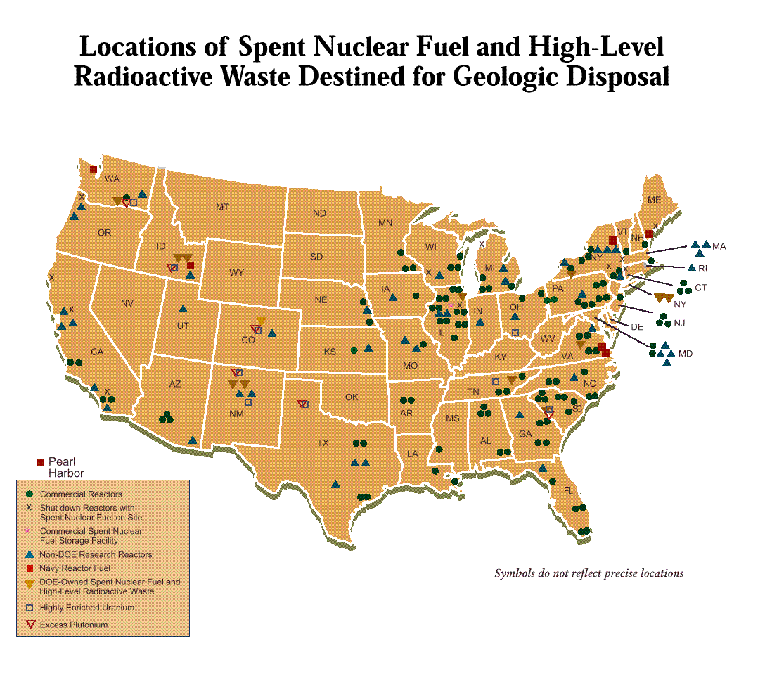
This map shows the location of the spent nuclear (Size 62KB)
This map shows the location of the spent nuclear 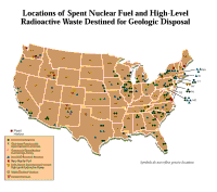 fuel and high-level radioactive waste destined for geologic disposal at Yucca Mountain if it is approved as a permanent geologic repository.
 (Size 60 KB) Part of the "Potential Rail Alignment Corridors Study" prepared for the U.S. Department of Energy. The map shows the revised potential rail routes for transportation of nuclear waste through Nevada to Yucca Mountain -- Source: U.S. Dept of Energy. (Size 60 KB) Part of the "Potential Rail Alignment Corridors Study" prepared for the U.S. Department of Energy. The map shows the revised potential rail routes for transportation of nuclear waste through Nevada to Yucca Mountain -- Source: U.S. Dept of Energy.
 (Size 64KB) Yucca Mountain Environmental Impact Statement (EIS) Map. The map depicts potential heavy haul truck routes for shipping spent nuclear fuel and High Level Waste to Yucca Mountain. The map also shows locations of potential intermodal waste transfer stations -- Source: U.S. Dept. of Energy. (Size 64KB) Yucca Mountain Environmental Impact Statement (EIS) Map. The map depicts potential heavy haul truck routes for shipping spent nuclear fuel and High Level Waste to Yucca Mountain. The map also shows locations of potential intermodal waste transfer stations -- Source: U.S. Dept. of Energy.
 In December 2003, the Department of Energy selected the Caliente rail corridor as its preferred route to bring nuclear waste into Nevada and to Yucca Mountain. The route was one of five possible corridors to transport the waste and approaches the Yucca Mountain site from the north of Nellis Air Force Base Range. Two southern corridors the Jean and the Valley Modified routes were eliminated because they run through the Las Vegas Valley -- Source: Nevada Appeal In December 2003, the Department of Energy selected the Caliente rail corridor as its preferred route to bring nuclear waste into Nevada and to Yucca Mountain. The route was one of five possible corridors to transport the waste and approaches the Yucca Mountain site from the north of Nellis Air Force Base Range. Two southern corridors the Jean and the Valley Modified routes were eliminated because they run through the Las Vegas Valley -- Source: Nevada Appeal
 In December 2007, officials from the Department of Energy informed the press that the Mina Corridor route for shipping nuclear waste to Yucca Mountain appears to be faster and cheaper to build than the Caliente Corridor -- Source: DOE In December 2007, officials from the Department of Energy informed the press that the Mina Corridor route for shipping nuclear waste to Yucca Mountain appears to be faster and cheaper to build than the Caliente Corridor -- Source: DOE
 (Size 59KB) Yucca Mountain Environmental Impact Statement (EIS) Map. Potential legal
weight truck routes for shipping spent nuclear fuel and High Level Waste to Yucca Mountain -- Source: U.S. Dept. of Energy (Size 59KB) Yucca Mountain Environmental Impact Statement (EIS) Map. Potential legal
weight truck routes for shipping spent nuclear fuel and High Level Waste to Yucca Mountain -- Source: U.S. Dept. of Energy
 (Size 65KB) Yucca Mountain Environmental Impact Statement (EIS) Map. This colored map shows detailed alternatives for a potential rail alignment corridors to Yucca Mountain -- Source: U.S. Dept. of Energy
 (Size 18KB) This is a magnified portion of a proposed rail route to Yucca Mountain. The map shows the route through Eureka and Lander Counties -- Source: Morrison-Knudsen, Boise, Idaho, 1997. (Size 18KB) This is a magnified portion of a proposed rail route to Yucca Mountain. The map shows the route through Eureka and Lander Counties -- Source: Morrison-Knudsen, Boise, Idaho, 1997.
 (Size 150KB) This is a detailed site map of the DOE proposed Carlin rail route in Eureka County. The shaded area marks the five mile wide corridor currently under study -- Source: Eureka County (Size 150KB) This is a detailed site map of the DOE proposed Carlin rail route in Eureka County. The shaded area marks the five mile wide corridor currently under study -- Source: Eureka County  . .
|