|
Part 3: AFFECTED
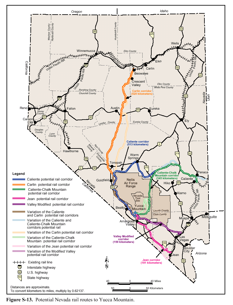
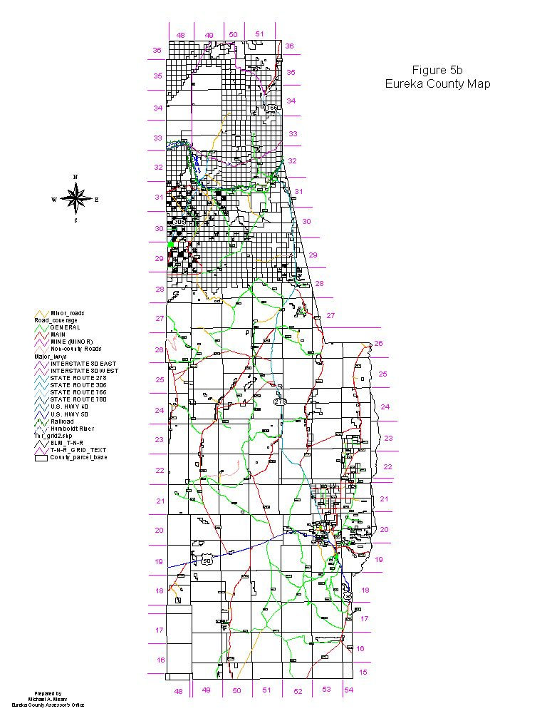
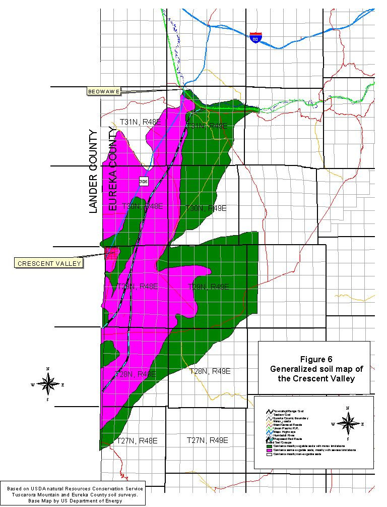
ENVIRONMENT A. Overview and General Setting Eureka County, located in north-central Nevada, comprises 4,176 square miles of land. Two major highways cross the County from east to west: Interstate 80 in the north and U.S. 50 in the south. The Interstate and the existing tracks of the UPRR roughly parallel the course of the Humboldt River. The seat of Eureka County government, the Town of Eureka, is located on U.S. 50 in the southeast portion of the County. (See location maps, Figures 5a, 5b, and 5c.) Eureka County’s population, according to the 2000 federal census, is 1,651. About two-thirds of the population lives in the southern portion of the County. Employment in 1997 consisted of 5,188 full-time and part-time positions (Fletcher, 2001). Mining is a major economic activity in the county. About 19 percent of the land area is private property, and about 81 percent is owned and managed by the United States government. In the northern portion of the County, a checkerboard pattern of private and public ownership predominates. B. The Natural Environment Climate and hydrology, generally Between the Union Pacific (UP) tracks near Beowawe and the proposed geologic repository at Yucca Mountain, the proposed Carlin rail corridor passes through 11 hydrographic basins. In northwestern Eureka County, the proposed corridor passes through the Crescent Valley hydrographic area, which the State Engineer has numbered Basin No. 54. It is a designated groundwater basin with a perennial yield of about 16,000 acre-feet per annum (afa) (USDOE 1999a). The topography of this region is typical of the Great Basin subprovince of the Basin and Range physiographic province, with north- to northeast-trending mountain ranges separated by alluvial valley floors (USDOE, 1999a; USDOI, 1999). The Crescent Valley is a semi-enclosed basin within the Humboldt River Basin, bounded on the west by the Shoshone Range, on the east by the Cortez Mountains, on the south by the Toiyabe Range, and on the north by the Dry Hills and the Humboldt River. The drainage basin is 45 miles long and 20 miles wide, with an area of about 750 square miles. The maximum elevation is 9,680 feet above mean sea level (amsl) at Mount Lewis in the Shoshone Range. The minimum elevation is 4,695 feet amsl at the north end of the Valley, near Beowawe (USDOI, 1999). General location map Eureka County map Figure 5c Location map, Beowawe and vicinity The terrain the proposed rail line would cross is relatively flat, with a gradual upslope from the connection point to the UPRR. The cross sections of the proposed corridor are also flat (Moore, 2001b). Low precipitation and humidity characterize the Crescent Valley’s climate, which is similar to that of northern Nevada generally. Local precipitation records at Cortez mine (elevation 5,000 feet) for the period 1967 through 1996 show an average annual precipitation of 8.37 inches. Records from Beowawe (elevation 4,696 feet) for the same period show an average annual precipitation of 8.77 inches, and for the 1941 through 1995 period, 7.94 inches. July through October are the driest months, and April through June are the wettest (USDOI, 1999; see also precipitation table, this reference, p. 4-13). The estimated total annual precipitation for the hydrographic basin is approximately 453,000 acre-feet, distributed as follows (USDOI, 1999): below 4,700 ft less than 8 inches average annual precipitation 4,700 to 5,800 ft 8 to 12 inches 5,800 to 6,600 ft 12 to 15 inches 6,600 to 8,000 ft 15 to 20 inches above 8,000 ft over 20 inches The center of the Crescent Valley consists of dry lake beds, separated from the Humboldt River by a low topographic divide at the north end of the valley. Water enters Basin No. 54 primarily as precipitation and is discharged primarily through evaporation and transpiration. Relatively small quantities enter as surface flow and groundwater underflow from the adjacent Carico Lake Valley at Rocky Pass, where Cooks Creek enters the southwest end of the Crescent Valley. Evapotranspiration in the valley provides a buffer that keeps recharge and discharge in balance. As discharge from consumptive uses increases and lowers the water table, discharge from evapotranspiration decreases (USDOI, 1999). Potential evaporation from the Basin is far greater than the amount of water entering the Basin from precipitation and inflow. There are no year-round water bodies in the Crescent Valley. Most streams are intermittent or ephemeral, draining toward the center of the basin. Some streams (e.g., Indian Creek) have flow throughout the year in locations where perched groundwater contributes to springs that flow into streams (USDOI, 1999). Only during times of exceptionally high flow do surface flows reach the lower slopes of the alluvial fans and reach the floor of the Crescent Valley. Runoff is likely to be higher from the Cortez Mountains, where the alluvial fans are steeper. Therefore, surface flow reaches the valley floor more frequently on the east side of the Valley (USDOI, 1999). Soils in this area are fragile and easily disturbed, and may not recover from disturbance on their own. Compaction of the soils increases erosion risk (Eureka County, 2000). Water resources Surface water. According to the United States Geological Survey (USGS), the baseflow of the Humboldt River at Beowawe was determined in 1992 to be 30.9 cfs (22,327 afa), consisting of 17.9 cfs of streamflow and 13 cfs of irrigation diversions (USDOI, 1999). None of the streams in the Crescent Valley are categorized as perennial streams for their entire length. A number of dry lake beds, or playas, occur in the central valley floor. The playas typically contain water temporarily after substantial storm and snowmelt events. Most of the runoff in the area is derived from snowmelt. A large percentage of annual precipitation falls as snow, and runs off from April through June. When spring-season rain coincides with snowmelt runoff, very high flows result. When available, surface water in some areas of Crescent Valley is used by wildlife and for mining, livestock, and irrigation. Runoff from the Crescent Valley does not flow into the Humboldt River, except for runoff from Coyote Creek, an intermittent creek that flows north from the Malpais, and several small ephemeral streams flowing north from the Dry Hills. At the south end of the Valley, surface water flow in Carico Lake Valley flows into Cooks Creek, which enters Crescent Valley through Rocky Pass and becomes dry after about one mile (USDOI, 1999; see also detailed descriptions of surface water drainages in the Crescent Valley for the Toiyabe Range and northeast Carico Lake Valley, the Cortez Mountains, the Dry Hills, and the Shoshone Range, this reference, p. 4-16). Numerous springs occur on the valley floor near the toes of the alluvial fans, with an estimated combined flow of up to 50 gpm. Near the Dean Ranch in Eureka County, there are eight to ten flowing wells and springs. The estimated total combined discharge rate of springs and seeps in the Crescent Valley is 250 to 300 afa. Three of the spring systems in the Crescent Valley are thermal: near the south extremity of the Dry Hills, at Hot Springs Point, five springs with a total flow of about 100 gpm; Chillis Hot Springs near Rocky Pass, with an estimated flow of about 10 gpm; and a spring west of Hand-Me-Down Creek at the base of the Cortez Range (USDOI, 1999). A point of interest, the Beowawe Geysers (now in use for geothermal energy production), is located southwest of Beowawe in the Whirlwind Valley (NDOT, 1989; A. Johnson, pers. comm., 2001). According to the DEIS for the proposed geologic repository (USDOE, 1999a), surface water resources in the portion of the proposed Carlin rail corridor between Beowawe and Austin include: (1) Tub spring, northeast of Red Mountain, 0.5 km from the corridor, (2) Red Mountain Spring, east of Red Mountain, 0.8 km from the corridor, (3) Summit Spring, west of the corridor and south of Red Mountain, 0.9 km from the corridor, (4) Dry Canyon Spring, west of Hot Springs Point, 0.4 km from the corridor, and (5) an unnamed spring on the east slope of the Toiyabe Range, southwest of Hot Springs Point, 0.8 miles from the corridor. Surface water quality data for the Crescent Valley area is limited. Three surface water samples were collected from Indian Creek, Mill Creek, and Fire Creek in 1992; three hot springs were also sampled in the same year. Constituents present in the samples included TDS, aluminum, arsenic, sliver, and others. In the Crescent Valley, 24 springs have been designated for quarterly monitoring, and seven springs for semi-annual monitoring. Flow, conductivity, pH, and dissolved oxygen are being monitored at four springs at Rocky Pass; six springs in the Toiyabe catchment; 12 springs in the Shoshone range; eight springs in the east Valley, and one in the peripheral area (USDOI, 1999). Groundwater. The saturated alluvial sediments beneath the floor of the Crescent Valley store a large volume of groundwater. Groundwater in the Cortez Mountains and the Shoshone Range surrounding the valley occurs mainly in joints and fractures in metamorphic and sedimentary bedrock. Most precipitation in the mountains travels downslope in ephemeral streams and enters the regional groundwater system as it crosses the alluvial fan. Large quantities of groundwater are stored in the alluvial aquifer beneath the valley floor, where the alluvium may be up to 9,300 feet thick in some places (USDOI, 1999). The water table at the Town of Crescent Valley is about 60 feet deep (elevation 4,730 feet), and at Beowawe, about 20 feet deep (elevation 4,691 feet). The flow direction is generally northeasterly, along the axis of the Basin (USDOI, 1999; see also map, this reference, figure 4.4.5.) Most of the proposed route crosses areas of the Crescent Valley where the groundwater lies close to the surface, within 15 to 20 feet, as indicated by the phreatophytic vegetation types, according to the BLM (Moore, 2001b). The natural flow of groundwater from the Crescent Valley discharges into the Humboldt River between Rose Ranch and Beowawe during normal flow conditions. Its contribution to the Humboldt River’s baseflow is about 0.9 cfs (650 afa). Another estimate places the average annual net discharge rate at between 700 and 750 afa (USDOI, 1999). Estimated groundwater pumpage for the Crescent Valley is estimated at less than 8,000 afa. Consumptive use is about 4,000 afa, and the balance is recharged. In addition, the Pipeline Project of Cortez Gold Mines (CGM), Inc. is authorized to use 2,367 afa consumptively (USDOI, 1999). The amount of consumptive use authorized for CGM may have increased with approval of the South Pipeline project. Based on sampling conducted in 1992 through 1997 in the Crescent Valley, alluvial water quality is generally good. It meets most primary and secondary drinking water standards, and is suitable for mining, irrigation, and livestock. It contains calcium, magnesium, and sodium cations and chloride, sulfate, and bicarbonate anions. The average concentration of manganese is higher than Nevada’s secondary water quality standard of 0.05 mg/liter. For the same period, sampling of the bedrock aquifer in the southwest portion of the Crescent Valley indicated that the water quality was similar to the alluvial water quality, with higher concentrations of minerals. The average concentrations were less than or equal to the primary drinking water standards, except for cadmium. The bedrock aquifer water is suitable for mining, irrigation, and livestock. It contains the same anions and cations as the alluvial water. The average concentrations are higher than Nevada’s secondary drinking water standards for TDS, flouride, iron, and manganese. These elevated metal concentrations are not unexpected (USDOI, 1999). Flooding. Flooding typically occurs in the Humboldt River Basin during the winter and spring. Winter floods are caused primarily by large rainstorms falling on low-lying snow or frozen ground. Winter floods are usually of a high volume and short duration. Spring floods occur with the snowmelt, which can be accelerated by heavy rains. Summer flash floods occur from localized high-intensity storms, and at times the runoff volume from flash floods may be greater than from spring snowmelt. Flash floods may deposit large volumes of debris and sediment on the uplands or the playa (USDOI, 1999). (See flood plain map, Figure 2.) Heavy flooding on the Humboldt River itself has been documented in: (1) December 1861 through January 1862, (2) December 1867 to January 1868, at Winnemucca, (3) May and June, 1884, (4) March through June, 1890, after the “white winter” of 1889-1890, (5) March 1907, where the Southern Pacific Railroad tracks in the lower basin were damaged, (6) February and March, 1910, when the Southern Pacific and Western Pacific tracks were damaged, (7) April and May, 1942, and January 1943, at the upper Humboldt River in Elko County, where railroad tracks and highways were washed out, (8) February through May, 1952, and (9) February 1962, when damaged occurred to U.S. 40 (now I-80) and the Western Pacific tracks in Elko County. Flooding destroyed over 30 miles of railroad track of the Eureka and Palisade Railroad in February and March, 1910 (Thompson, 1987). According to the Federal Emergency Management Agency (1998), the area of the 100-year flood includes land adjacent to the north and south banks of the Humboldt River, as well as an area running south from Beowawe (following Coyote Creek at the north end for about four miles) at least 15 miles in length, and passing about 1.5 miles to the east of the Town of Crescent Valley. Generally speaking, the width of this area is greater than one mile. The area of the 100-year flood also includes an area less than ¼ mile wide, running generally east-west across the Crescent Valley, joining with the larger north-south flood area about three miles southeast of the Town of Crescent Valley, and following the alignment of Thomas Creek. (See map, Figure 2.) The Crescent Valley has been subject to recent flooding at depths up to four feet in some locations (Eureka County, 2000). Water use and water rights. Nevada’s State Engineer classifies the Crescent Valley hydrographic basin as a designated basin, in which withdrawal and use of groundwater is regulated. Evaporative losses may be treated as a consumptive use and accounted as a water right, at the discretion of the State Engineer (USDOI, 1999). Cortez Gold Mines (CGM), Inc., holds senior certificated water rights for agricultural and mining use in Crescent Valley. CGM filed multiple applications with Nevada’s Division of Water Resources (DWR) to appropriate water for mining, milling, dewatering, and domestic purposes. Each application covers a 160-acre quarter section. The total continuous diversion rate, combined, would be 67 cfs (30,074 gpm). The DWR approved the applications. If the proposed diversion is greater than 67 cfs, or if consumptive use is greater than 2,362 gpm, additional water rights are required. CGM has filed additional water rights applications (USDOI, 1999; see also inventory of water rights for southern part of the Crescent Valley, this reference, figure 4.4.11 and table 4.4.10). The only municipal groundwater rights in the hydrographic basin are those of the Town of Crescent Valley (USDOI, 1999). According to the DWR, as of 1997, surface water rights existed for springs and streams in the Crescent Valley, including: Upper Indian Creek; Mud Spring; Corral Canyon; Hot Springs Point; Scotts Gulch; Dewey Dann Creek; Duff Creek; Fire Creek; Frenchie Creek; Mule Canyon; Brock Canyon; Hand-Me-Down Creek; Four Mile Canyon; Little Cottonwood Creek; and Mill Canyon. Historic use of surface water from Indian Creek is reported at the Dean Ranch (USDOI, 1999). Seismicity The BLM has inventoried historic earthquake activity in this area. For the nearby South Pipeline project in Lander County, the BLM said that the operating basis earthquake (OBE) had a peak ground acceleration of 0.21 g and an expected return period of 450 years, and that seismic events could result in slope failures or structural damage to mine facilities, if the OBE were exceeded (USDOI, 1999). Air resources The Crescent Valley Air Basin (CVAB) includes the area bounded by the crest of the Shoshone Range and the Tuscarora Mountains to the north and west, and the crest of the Toiyabe and Cortez Mountains to the south and east. Its boundaries are the same as the boundaries of the Crescent Valley hydrographic basin. The Crescent Valley is a high desert environment, arid to semi-arid, with bright sun, low annual precipitation, and large daily temperature variations. The climate is controlled by the topography to the west, particularly the Sierra Nevada range. The average annual temperature at the Elko airport is 46 degrees F. The annual average temperature at Cortez in 1997 was 53 degrees F, and the recorded range of temperatures was from -1 degree F to 98 degrees F (USDOI, 1999). Prevailing winds at the Cortez station in 1997 were from the east at 7 mph. The estimated annual average mixing height in the area of CGM’s Pipeline Project at the southern end of the Crescent Valley is 250 feet (a.m.), and 2,400 feet (p.m.). Dispersion conditions at the Cortez station were classified as good, 70 percent of the time in 1997 (USDOI, 1999). From a regulatory perspective, the CVAB is unclassified for all pollutants for which a national ambient air quality standard (NAAQS) has been established. The nearest nonattainment area for particulate matter up to 10 microns in diameter (PM10), carbon monoxide (CO), and ozone (O3) is Washoe County, Nevada, about 100 miles to the east. The nearest nonattainment area for sulfur dioxide (SO2) is the Steptoe Valley, about 100 miles to the east-southeast (USDOI, 1999). Nevada’s Bureau of Air Quality (BAQ) was not monitoring air quality in the CVAB as of 1999. CGM monitored PM10 at two locations: the Cortez station and 1.5 miles southwest of the Pipeline mill. For 1997, the average 24-hour and annual average concentrations of PM10 were from 22 to 27 micrograms per cubic meter (ug/m3). The maximum 24-hour PM10 concentration was in the range of 83 to 119 ug/m3. For PM10, the BAQ assumes a background concentration of 10.2 ug/m3 for both the 24-hour and annual average. However, for the Pipeline project, BAQ selected a background value of 22 ug/m3, based on the 1997 monitoring. The BAQ has not defined background concentrations of CO, nitrogen dioxide (NO2), and SO2 for the CVAB (USDOI, 1999). The U.S. Environmental Protection Agency (USEPA) designates Class I airsheds to prevent further deterioration of air quality in national parks and wilderness areas created before 1977, plus additional areas. The nearest Class I airshed to the Crescent Valley is the Jarbidge Wilderness Area, about 118 miles to the northeast (USDOI, 1999). Vegetation and soils The area of Eureka County that would be affected by the proposed rail corridor is part of the central Great Basin. It is a cold desert with low rainfall. There are three main plant communities in the valleys and the lower mountain slopes: the shadscale (Atriplex confertifolia) community; the sagebrush (Artemesia tridentata) community; and the pinon-juniper (Pinus monophylla, Pinus adulis, Juniperus osteosperma) community. The floor of the Crescent Valley consists of finer grained sediments and deep-rooted phreatophyte vegetation types, primarily saltgrass and greasewood, which thrive on the shallow groundwater in the area (USDOI, 1999). According to the Department of Energy, the predominant vegetation in the proposed Carlin corridor, from Beowawe to Beatty Wash, includes salt desert scrub (57 percent), sagebrush (28 percent), and greasewood (7 percent). The DOE says there are five riparian areas between Beowawe and the south end of Grass Valley: at Skull Creek, Steiner Creek (ephemeral), Ox Corral Creek (ephemeral), Water Canyon, and Rye Patch Canyon (USDOE, 1999a). Special status plant species in the area include Eastwood’s milkweed (Asclepias eastwoodiana) and Elko rockcress (Arabis falsifructa). Both are considered sensitive by the Bureau of Land Management and are on the watch list of the Northern Nevada Native Plant Society. The habitat preference of the former species is low alkaline clay hills or shallow, gravelly drainages. It occurs in association with shadscale, budsage, greasewood, and horsebrush, at elevations from 5,300 to 6,900 feet. The latter species prefers moderate to steep north-facing slopes in light sandy ash soils, in the sagebrush/rabbitbrush/bluegrass community, from 5,300 to 6,100 feet (USDOI, 1999). According to Nevada’s Natural Heritage Program, there are about 12 mapped occurrences of sensitive species in the northern half of Eureka County. One such site is the Kobeh Valley macrosite of the Hot Springs Hill site. It is ranked 1 (highest) for biodiversity significance, protection urgency, and management needs. It is on lands managed by the BLM at an elevation of 6,120 feet, and is approximately 0.3 miles wide. Common names of the plants found at the site include the one-leaflet Torrey milkvetch and the Monte Neva paintbrush (NNHP Scorecard, 1998). Noxious weeds are a major problem in Nevada and the western United States. They threaten the livelihood of all who depend on the use of the range; they are easily spread by wind, livestock, other animals, persons on foot, and motor vehicles; and they are difficult or impossible to control once established. Disturbed soils are especially vulnerable to colonization by noxious weeds (Eureka County, 2000). Infestations of hoary cress or whitetop (Cardaria draba) and saltceder or tamarisk (Tamarix sp.) are present in the vicinity of CGM’s Pipeline project at the south end of the Crescent Valley. The mine’s monitoring and control plan identifies five other noxious weed species suited to the soils, climate, and conditions in the area, including: (1) spotted knapweed (Centaurea maculosa), (2) diffuse knapweed (Centaurea diffusia), (3) yellow starthistle (Centaurea solstitialis), (4) Scotch thistle (Onopordum acanthium), and (5) leafy spurge (Euphorbia esula) (USDOI, 1999). Soils in the Crescent Valley are generally high in alkalinity. The valley floor includes playa deposits that consist of finer-grained sediments. The Crescent Valley alternative corridor for the proposed rail line crosses an area of alkali flats. These soils are typically difficult to revegetate following disturbance, especially in an arid climate (Moore, 2001b). (See generalized soil map of the Crescent Valley, Figure 6.) Wildlife and fish Mule deer occupy the mountainous portions of the Shoshone, Toiyabe, and Cortez ranges, where they prefer the elevations and vegetation above the valley floors. The deer winter at elevations where water, shelter, and forage are more readily available. (USDOI 1999, p. 4-125) Winter deer range exists in the vicinity of Beowawe, including the Horseshoe Ranch, and a deer migration route connects winter range in the Dry Hills, northeast of Hot Springs Point, and summer range to the north. According to McKenzie (pers. comm., 2001), some mule deer are found year-round in the vicinity of the Humboldt River. Nevada’s Division of Wildlife (NDOW), the BLM, and others have spent money restoring winter range in this area (Eureka County, 2000). The Crescent Valley also supports an expanding population of pronghorn antelope, which NDOW transplanted into the area. The animals are now breeding there (USDOI, 1999). According to NDOW, mountain lion populations exist in the mountainous portions of the Shoshone, Toiyabe, and Cortez ranges as well, and bobcats and badgers would also be expected in the area. Non-game mammals that exist in the vicinity include the kit fox, gray fox, and coyote, plus cottontail rabbit, white-tailed jackrabbit, mice, ground squirrels, and other rodents (USDOI, 1999). The pygmy rabbit, a sensitive species, is also known to inhabit the corridor area (McKenzie, pers. comm., 2001). The BLM reports that sage grouse are commonly found in the area of the Shoshone Range, northwest of the site of CGM’s Pipeline project (USDOI, 1999). Critical wildlife habitat near the corridor of the proposed rail line includes a sage grouse strutting area, or lek, located southeast of Beowawe, according to a DOE contractor (Moore, 2001b). Chukar use the steep, rocky, mountainous habitats in the Shoshone Range. Blue grouse and Hungarian (gray) partridge may inhabit the upper slopes of Mount Tenabo, according to NDOW. Game bird species that are known to occur in small numbers in the vicinity of the Pipeline project include the mourning dove, California (Valley) quail, and Wilson’s snipe, which use the valley floor and foothill habitats as foraging areas (USDOI, 1999). Figure 6Generalized
soil map of the Crescent Valley
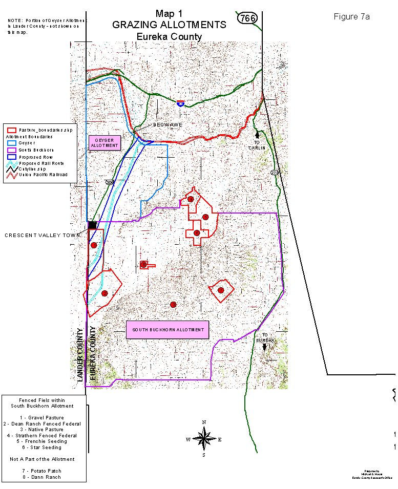
The Crescent Valley also supports scattered families of burrowing owls, which are on Nevada’s list of protected animals. An active nest has been observed, north of CGM’s Pipeline project area, since 1991, and there have been sightings of burrowing owls in the vicinity. Various raptors also frequent the Crescent Valley, including year-round residents, wintering hawks, and spring nesting birds. The Valley has a lack of perch and nesting sites in various areas (USDOI, 1999). One raptor present in the Valley is the Ferruginous hawk (McKenzie, pers. comm., 2001). Non-game avian species in this vicinity include horned larks, sage thrashers, western meadowlarks, Brewer’s and red-winged blackbirds, sage and Brewer’s sparrows, swallows (various), and possibly black-throated sparrows. Western grebes nest at the Ruby Lakes and may pass through the Crescent Valley area. In the specific vicinity of CGM’s pipeline project, migratory waterfowl and shorebirds are present, probably due to the operation of infiltration sites for dewatering (USDOI, 1999). Regarding fish, surveys conducted for CGM’s Pipeline project in 1996 found most streams in the area in a degraded condition, and mountain springs adversely affected by livestock and wild horses. Indian Creek supports a naturally sustaining population of non-native brook trout, and Frenchie and Duff Creeks supported populations of brook and brown trout when sampled in the mid-1980s, according to NDOW (USDOI, 1999). (See also USDOI, 1999, pp. 4-126 to -128, for tables of 22 special status animal species that occur or may occur in the vicinity of CGM’s Pipeline project, and their habitat preferences.) Range There are two BLM grazing allotments in the Eureka County portion of the Crescent Valley, to the north and south of the Town of Crescent Valley respectively, according to McKenzie (2001). (See Figures 7A, 7B, and 7C, maps of Crescent Valley grazing allotments.) Geyser allotment. The Geyser allotment contains the northwest part of the Crescent Valley, plus the Eureka County portion of Whirlwind Valley and most of the north slope of the Argenta Rim, which extends into Lander County. The south, east, and north boundaries of the allotment are fenced. The south boundary runs about six miles across the Valley floor from the Town of Crescent Valley. The allotment includes 98,742 total acres, of which 52,107 acres are private property and 46,635 acres are managed by the BLM. The primary sources of stock water for the Crescent Valley portion of the Geyser allotment are: a canal from the Humboldt River, Cold Springs, a pipeline along the eastern border, and hot springs in the southeast corner of the allotment. The BLM has licensed Zeda, Inc., to use 1,227 animal unit
months (AUM) from November 15 to March 15 on the Geyser allotment. Due to the presence of private land, Zeda,
Inc., can run 2,231 AUMs. (One AUM is
defined as one 1,000 pound cow or one 1,000 pound cow with a calf less than six
months old, for a period of one month.)
Due to the topography, the livestock tend to Figure 7a Crescent Valley grazing allotments Geyser Allotment South Buckhorn Allotment remain near where they are turned out and, therefore, most of the use is in the Crescent Valley portion of the allotment. South Buckhorn allotment. The South Buckhorn allotment contains the Eureka County portion of the Crescent Valley, south of the Town of Crescent Valley, plus a large part of the Cortez Mountains and the west side of Pine Valley. The allotment is completely fenced, except for a small, steep portion on the south boundary. It consists of 315,323 total acres, of which 222,004 are private, and 93,319 are public and managed by the BLM. Fences and topography divide the allotment into the following separate fields: Strathern field, Gravel field, Frenchie seeding; Star field; Upper Brock; Potato Patch; Native pasture; and Dean Ranch. The primary sources of stock water in the Crescent Valley portion of the South Buckhorn allotment are: the hot spring east of the Town of Crescent Valley, water from the Town, flowing wells and springs in the Valley bottom, and springs and live streams flowing from the Cortez Moutains. The BLM has licensed Cortez Joint Venture (CJV) to use 6,563 AUMs on the South Buckhorn allotment from April 16 to October 31, plus 273 AUMs of suspended non-use. The primary area for this use is in the western half of the allotment. At the present time, CJV is not running livestock. There are also five other users on this allotment: Slagowski Ranches, Inc. (7,497 AUMs plus 347 AUMs suspended non-use, mostly in the eastern portion of the allotment); Harold Rother (3,774 AUMs plus 157 AUMs suspended non-use, mostly in the eastern portion of the allotment); Hale Bailey (1,260 AUMs plus 52 AUMs suspended non-use, mostly in the eastern portion of the allotment); Tom Connoly (595 AUMs plus 25 AUMs suspended non-use, primarily in the extreme southwest portion of the allotment, with interchange with an additional allotment in Grass Valley); and the Dann sisters and Western Shoshone National Council (about 15,000 AUMs, primarily in Native pasture, without federal grazing permits or authorization). Horses and burros. There are two wild horse herd areas in Lander County, but none in the Crescent Valley portion of Eureka County. The Dann sisters have about 800 horses. There have been infrequent reports of wild burros, south of the Town of Crescent Valley (McKenzie, 2001). Scenic resources A rhythmic pattern of isolated north-south trending mountain ranges and wide basins with broad, open vistas characterizes the scenery of the Great Basin. One sees vast areas of sagebrush and scattered grasses covering the valley basins, infrequent linear patterns of riparian willows and cottonwoods outlining the larger drainages, and--at higher elevations--mixed shrub and scattered pinon-juniper forests covering the mountains (USDOI, 1999). Scenic resources in the general vicinity of the Crescent Valley that could be affected by the proposed rail corridor include: ranches; stage stops; hot springs; graveyards; historic mines; the Humboldt River; and various geologic formations (Eureka County, 2000). The Bureau of Land Management has classified the visual resource class of the corridor in Eureka County as a class IV (least value) (USDOE, 1999a). C. The Human Environment Cultural resources The wide area surrounding the Crescent Valley, including Grass Valley, the northern Toiyabe Range, the Simpson Park Mountains, Beowawe, Battle Mountain, the Humboldt River, and beyond, comprises a prehistoric and ethnographic area of interest. The land that would be occupied by the proposed rail corridor falls within the traditional territory of the Western Shoshone, whose people refer to themselves as the “Newe” (USDOI, 1999). Anthropologist Mary Rusco studied places important to Newe beliefs and practices at the north end of the Crescent Valley in the Beowawe area. She concluded there are two kinds of highly important areas for religious purposes: springs, and the most prominent land forms in the area. Other anthropologists have identified power spots that always include springs, mountains, and the tops of prominent, isolated rock formations. There is a traditional Newe concern for springs. “To-sam-boi” is the name given to the hot spring area at Beowawe by Newe elder Eunice Silva in 1997 (USDOI, 1999). Western Shoshone tribes presently living in the general vicinity of the rail corridor include, from west to east, the Yomba Shoshone, the Duckwater Shoshone, and the Ely Shoshone. The Consolidated Group of Tribes and Organizations says that the proposed rail corridors pass through traditional holy lands of the Southern Paiute, and correspond or are adjacent to ancient pathways and trails (USDOE, 1999a). Regarding European settlement of the general area around the Crescent Valley, the 19th century emigrant trail intersected the Humboldt River, west of Carlin and Emigrant Pass, at Gravelly Ford, about three miles east of the present site of Beowawe. (See Figure 5c.) The River had a solid gravel bottom there, where wagons could cross and reach excellent grasslands on the south side. The Whirlwind Valley (its present name), farther to the west, also provided a source of grass and springs. At Gravelly Ford, emigrant parties camped, before crossing the River to the south side or taking a route over bluffs north of the River, eventually reaching the River again, north of the present headquarters of the Horseshoe Ranch. Most parties took the easier trail on the south side. The national wagon road, connecting Nebraska to California, followed the California Trail along the Humboldt River. The road was designated in 1856. In 1868, Beowawe and Carlin were founded on the line of the Central Pacific Railroad, the tracks for which were built along the Humboldt River route of the California trail (Thompson, 1987). In the vicinity of Gravelly Ford is a cemetery, where Lucinda Duncan was buried in 1863. Crews working on the construction of the Central Pacific Railroad relocated the grave in 1869, and erected a large cross on the site. Subsequently, the fanciful legend of the “Maiden’s Grave” grew regarding the site (The trail). Also, in Lander County, immediately adjacent to the Eureka County line, about three miles east of NV 306 in section 24, maps show a public lands cemetery (USDOI, 1999). The Pony Express route crosses Eureka County from east to west, south of the Crescent Valley and north of the Town of Eureka. In 1860, a Pony Express station was established at a location known as Simpson Park. During the last few months of Pony Express operations and through most of the 1860s, the Overland Mail Company also used the Simpson Park station as a stagecoach stop (Godfrey, 1994). The site of Simpson Park is located in southeastern Lander County, south-southwest of the Town of Crescent Valley. Population and demographics According to the 2000 census, the current population of Eureka County is approximately 1,600 persons. The census reported 548 persons living in the Beowawe census county division (CCD) and 1,103 persons in the Eureka CCD. Whites make up the largest demographic group, accounting for 88 percent of the population in the Beowawe CCD and 89 percent in the Eureka CCD (USDOC, 2000a). The minority population does not appear to have increased since the 1990 census, which reported a minority population for Eureka County of 11 percent (USDOE, 1999a). Looking at the last 20 years, the population of Eureka County increased 29 percent from 1980 to 1990 (changing from 1,198 to 1,547 residents). Growth slowed appreciably in the 1990 to 1997 period. The population of Beowawe declined by about 12 percent, to 51 residents, and the population of the Town of Crescent Valley declined about 10 percent, to 240 residents. However, another estimate placed the population of the town, in 1998, at between 500 and 600 residents (USDOI, 1999). Growth rates for the County are expected to be less than Nevada’s average. In 1998, Nevada’s state demographer projected Eureka County’s 2007 population at 2,250 persons (USDOI, 1999). Land ownership Although the percentage of private land within the proposed Carlin rail corridor is less than 4 percent, within Eureka County, the corridor includes about 54 percent private land (for the primary option) or 59 percent private land (for the Crescent Valley option) (R. Moore, pers. comm., 2001). Almost 60 percent of the assessed private parcels of land in Eureka County are within 10 miles of the proposed corridor, which would affect 1,730 acres of private land along its length (Eureka County, 2000). (See Figure 8, map of land ownership in northern Eureka County, and Figure 9, map of land ownership as affected by the rail corridor.) Economy Eureka County employment, as of 1997, consisted of 5,188 full-time and part-time jobs. Thus, there are about 3.1 jobs per resident. Personal income in 1997 was $281.1 million by place of work, and $40.7 million by place of residence. The labor force residing outside Eureka County represented 80 percent of the work force, 83 percent of the personal income, and 88 percent of wages and salary earned in 1997. Unemployment during the first quarter of 2001 was 2.7 percent (Fletcher, 2001). Figure 8Map
of land ownership in northern Eureka County
Figure 9Map
of land ownership in northern Eureka County, as affected by rail corridor
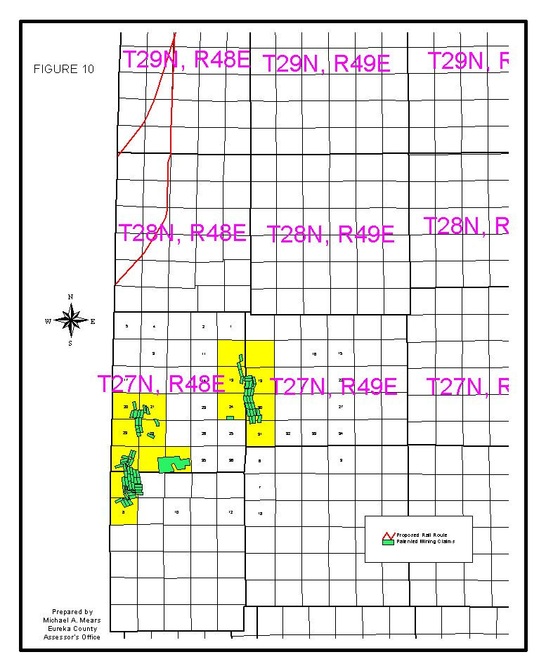
Gold mining is very important to Eureka County’s economy. In 1996, mining accounted for 90.8 percent of total earnings, followed by earnings in construction and state and local government (USDOI, 1999). The County experienced a drop in total employment from 1990 to 1997, including a marked decrease during the 1993 to 1996 period, reflecting a slowdown in the mining industry. From 1990 to 1997, the unemployment rate varied between 4.2 percent and 10.90 percent. As of the first quarter of 1997, the largest employers in Eureka County were (USDOI, 1999): Newmont Gold Co. (2,200 to 2,299) Barrick Goldstrike Mines, Inc. (1,700 to 1,799) Eureka County (100 to 199) Newmont Exploration Ltd. (100-199) Eureka County School District (100-199) Mine Service and Supply Co., Inc. (less than 100) Stewart Brothers Drilling Co. (less than 100) Small Mine Development (less than 100) Nevada Department of Transportation (less than 100) Owl Club (less than 100) As of 1999, Cortez Gold Mines, Inc. (CGM) had 456 employees at its location in Lander County, southwest of the Town of Crescent Valley. Of these employees, 94 resided in Crescent Valley and Beowawe (making up about 32 percent of the population), 62 in Battle Mountain, 51 in Carlin, and 249 in Elko and Spring Creek. During the life of its Pipeline project, the CGM work force is expected to fluctuate between 450 and 500 employees (USDOI, 1999). Mining production is expected to decrease 25 percent in the next five years, 60 percent in the next 14 years, and 100 percent by 2018 unless new reserves are discovered, according to a study by the Center of Economic Development at the University of Nevada, Reno (Fletcher, 2001). In addition to gold mining, agriculture provides a smaller but stable economic base over an extended time period. The agricultural economy consists of four sectors: range beef cattle, alfalfa hay, timothy hay, and native hay. Travel, including tourism and recreational travel, has been more important to the economy in recent years. Lodging, eating, drinking, and retail sales establishments provide enhanced services to local residents, due to outside money circulating through the local economy from visitors (Fletcher, 2001). Housing As of 2000, the federal census reported 1,025 housing units in Eureka County, of which 666 were occupied (491 by their owners and 175 by renters). There were 359 vacant units, according to the census, of which 64 were maintained for seasonal or recreational use. However, the Eureka County assessor reports that there are 920 housing units on the tax rolls, consisting of 236 single-family homes, 28 duplexes, 4 four-plexes, and 640 mobile homes. The assessor says there are only about 25 vacant units--10 in the north and 15 in the south, primarily near the Town of Eureka. The assessor’s data may be more realistic than the U.S. census data, considering the County’s stable population and low unemployment (Fletcher, 2001). In the Crescent Valley and Beowawe area, there are no traditional hotels or motels. There are three recreational vehicle parks in the Crescent Valley, with a total of 60 spaces (USDOI 1999). Mining and minerals In the southern portion of the Crescent Valley and surrounding mountains, substantial mineral exploration and production of metallic and industrial minerals has occurred, and continues to occur. Gold and barite have dominated mineral production, but historical production includes silver, turquoise, and lesser amounts of copper, lead, and arsenic. (USDOI 1999, p. 4-4) Historic and existing mining projects in Eureka County, in the southern Crescent Valley, include the Mill Canyon gold mine (with 18 acres of surface disturbance) and the Hot Springs sulfur mine (with 5 acres of surface disturbance) (USDOI, 1999). The Mill Canyon site was active prior to 1950 and was the subject of additional mineral exploration in 1988. The operations there resulted in some groundwater contamination. The Hot Springs sulfur mine is an inactive, historic open pit mine located near Hot Springs Point, east of the Town of Crescent Valley. It consists of roads, pits, dumps, and trenches (USDOI, 1999). In the general vicinity of the southern Crescent Valley, mineral exploration in the next ten to 15 years may disturb up to 150 acres of land in the Cortez Range, up to 100 acres of land in the Toiyabe Range, up to 100 acres in the Shoshone Range, and about 150 acres in valley areas. Activity in the Cortez Range will focus on Horse Canyon, the Cortez trend, and the Buckhorn area (USDOI, 1999). There are 92 patented mining claims in Eureka County within 10 miles of the proposed Carlin rail corridor and the existing UPRR tracks. Two patents are located near Carlin in T32N, R48E. The balance are south of the Town of Crescent Valley in T26N, R31E (31 patents); T26N, R49E (10 patents); T27N, R48E (23 patents); and T27N, R49E (26 patents). Numerous unpatented mining claims have also been recorded with Eureka County in various locations in the Crescent Valley (Mears, pers. comm., 2001). (See Figure 10, map of patented mining claims.) Adjacent to the Eureka County-Lander County line in the
southern Crescent Valley, Cortez Gold Mines, Inc. (CGM) operates mining and
processing facilities in three main areas.
The Cortez facilities are on the east side of the Crescent Valley, on
the west flank of the Cortez mountains in Lander County, about six miles west
of Horse Canyon. The Gold
Acres/Pipeline facilities are on the southwest side of the Crescent Valley in
the Shoshone Range, in Lander County, about eight miles northwest of the Cortez
area. Finally, the Horse Canyon
facilities are located about two miles east of Mount Tenabo in the Cortez
Mountains, in Eureka County, and include the Horse Canyon Pit and a deposit
known as the “south silicified zone”.
The company also operates the Cortez gravel pit, located on the south
side of the Gold Acres haul road, about one mile west of the Cortez facilities. The gravel from the pit is used for
concrete, road surfacing, and other construction and operational uses. The approved surface disturbance for the pit
is about 100 acres, and 75,000 cubic yards of gravel may be used in a ten year
period for CGM’s Pipeline project (USDOI, 1999). Map of patented mining claims in and adjacent to the Crescent Valley These various CGM facilities are located on the Battle Mountain-Eureka mineral trend, within a joint venture area established by Placer Dome U.S. and Kennecott Minerals (USDOI, 1999; see also mineral rights ownership map, this reference, Figure 1.2.1). The Pipeline and South Pipeline projects of CGM are named after a water pipeline that crosses the area and supplies water to the Gold Acres operations. As of 1999, CGM was operating the Pipeline project at a rate of up to 250,000 tons/day, with plans to operate through 2004, and a proposal to expand with the South Pipeline project (consisting of both an expansion to the southeast and a water infiltration project), which would extend the life of the project by about 10 years. (USDOE, 1999a; USDOI, 1999). Mineral exploration continues within the Pipeline/South Pipeline project area and in the vicinity of the Cortez open pit, where drilling has defined potential economic ore reserves. CGM is not backfilling the Cortez pit, due to the potential for economic mineralization nearby (USDOI, 1999). Approved surface disturbance associated with CGM’s Pipeline and Crescent waste rock dumps is about 667 and 114 acres, respectively, with a combined capacity to store about 250 million tons of waste rock. The height of the waste rock dump is up to 200 feet above grade (USDOI, 1999). At the Pipeline mine site, dewatering operations pump groundwater at a maximum annual average rate of 30,000 gpm. Actual pumping rates are substantially lower than the maximum. Water is pumped from wells around the Pipeline open pit, and most is returned to the same groundwater basin (i.e., Basin No. 54, the Crescent Valley hydrographic basin) through a series of infiltration basins. Upon approval of the South Pipeline project, the maximum rate of groundwater pumping increased to 34,500 gpm (USDOI, 1999). Infrastructure and public facilities Aviation. Eureka County maintains a general aviation airport, east of the Town of Crescent Valley, and partially within the corridor of the proposed Carlin railroad line. Energy. Sierra Pacific Power Company (SPP) provides electric power to CGM’s Pipeline mine and process area via a 120 kilovolt transmission line from the Battle Mountain area. The line connects the Reese River substation in Battle Mountain to the Cortez Tap Switching Station in Whirlwind Valley, about 12 miles away. The line then proceeds 23 miles to the south to a substation at the Pipeline mill (USDOI, 1999). Duke Energy operates a bulk propane and oil dispensing facility in Beowawe. Propane and oil are stored for delivery to area residents and businesses through distributors (V. Drenon, pers. comm., 2001). Government. The Board of Eureka County Commissioners oversees County government and administers the budgets of the Town of Eureka and the Town of Crescent Valley. Various special districts are governed by the Board of County Commissions or by separate boards. A town advisory board participates in governance for the Town of Crescent Valley, as set forth in State statutes. Medical facilities. There is a medical clinic in the Town of Crescent Valley, but there are no health care facilities in Beowawe. Residents of and visitors to the affected area obtain most medical, dental, and pharmacy services in Ely, Elko, Reno, Battle Mountain, and Salt Lake City (USDOI, 1999; A. Johnson, pers. comm., 2001). The nearest hospitals are Elko General Hospital and Battle Mountain General Hospital (Eureka County, 2000). Parks. The Town of Crescent Valley includes a park with basketball and tennis courts, a picnic area, a ball field, and a playground. Fairgrounds for equestrian events are located adjacent to the Town. There is a playground at the Beowawe school building, which is used for community recreation. Police, fire protection, and emergency response. Law enforcement services in Eureka County are provided by the Eureka County Sheriff and the Nevada Highway Patrol. There is a new fire station in a new building in Beowawe (Drenon, pers. comm., 2001). Nevada’s rural areas have extremely limited (or no) capability for initial response to accidents involving spent nuclear fuel and high-level radioactive waste (Eureka County, 2000). Railroads. The UPRR railroad track, which passes through Eureka County near the Humboldt River and Beowawe, is--in this location--an unusual double track. The tracks were originally single tracks owned by the UPRR and the SPRR. The single-track lines were operated jointly under a paired track agreement for approximately 180 miles, between Alazon (near Wells, NV) and Wesco (near Winnemucca, NV). The UPRR acquired the SPRR and now owns both sets of tracks (Moore, 2001a). Westbound traffic uses the original SP track, and eastbound traffic uses the original UP track. Although the two tracks share right-of-way in some locations, they are in separate rights-of-way for most of the distance between Wells and Winnemucca, sometimes separated by as much as four miles. In the vicinity of Beowawe, the eastbound track is the southern track. Trains operate under automatic block signal control, and are not controlled directly by dispatchers. Most passing sidings have been removed. Crew change points are at Elko, NV, and Carlin, NV. Traffic on the paired UP and SP tracks is heavy, at about 30 trains per day (Moore, 2001a). An intermodal (rail-to-truck) freight transfer facility has been constructed on the existing UPRR line at Dunphy, about 10 miles north of Beowawe. Owners of mines in Eureka County are considering construction at this site of a facility to produce ethanol for use as fuel (Hutchings, pers. comm., 2001). Schools and libraries. The Eureka County School District (ECSD) operates a junior-senior high school with a capacity of 200 students; an elementary school with a capacity of 240 students; the Crescent Valley elementary school, with a capacity of 180 students; and 12 school buses. The Great Basin Community College offers classes for adults (USDOI, 1999). Current enrollment at the Crescent Valley Elementary School, located at 444 4th Street in the Town of Crescent Valley, is about 60 students in grades K through 6 (CVES, undated). The school building in Beowawe is not used for classes, since students from Beowawe attend school in the Town of Crescent Valley, but the building is used as a recreation center, maintained by Eureka County’s juvenile probation office. The building provides basketball courts and other recreation activities for adults and children (Drenon, pers. comm., 2001). A multi-county library district for Elko, Eureka, and Lander counties operates libraries in both the Town of Crescent Valley and Beowawe. Social services. Eureka County operates a senior center for the Crescent Valley area, with a staff of 4 persons, serving lunch to 25 to 30 persons per day. The center also assists persons with access to social services. Solid waste. Hoss Disposal collects solid waste from the Town of Crescent Valley and transports it to the Eureka landfill. The landfill, which is owned and operated by Eureka County, is a Class II municipal landfill. According to County records for the second quarter of 2001, the average total tonnage received by the landfill was 133 tons per month; the facility has enough remaining capacity for 30 years. At CGM’s Cortez and Pipeline project areas, all trash and refuse is hauled to an approved Class III-waivered landfill located on private land in the project area (USDOI, 1999). Streets, roads, and highways. Interstate 80, Nevada 278, Nevada 306, and U.S. 50 are the main improved roads in Eureka County. These are important routes for mining, commerce, and the mobility of residents and visitors. A network of County roads provides access to public lands, private property, and mining claims (Eureka County, 2000). Nevada 306 is the principal access road through the Crescent Valley from Beowawe to the CGM mine projects. The road terminates at the junction with Lander County 225, in the vicinity of the Pipeline project (USDOI, 1999). (See Figures 5A, 5B, and 5C, location maps.) There is a County yard at Beowawe. Wastewater. Sewage disposal in the Crescent Valley, including Beowawe and the Town of Crescent Valley, occurs through private septic systems. Water. Eureka County supplies water to about 247 customers of the Crescent Valley water system. The County maintains 3 wells, a distribution system, and three storage tanks with a total capacity of 660,000 gallons. The balance of residents and visitors to the Crescent Valley rely on wells and surface springs for water (Drenon, pers. comm., 2001; USDOI, 1999). Most of the wells and springs north of the Town of Crescent Valley are located between Nevada 306 and the proposed rail line right-of-way. There are also a number of flowing wells south of the Town, most of which are located in the area between the primary corridor and the alternative corridor to the east (Moore, 2001b). Potable water at CGM’s Pipeline project and Cortez facilities is provided by bottled water or a fresh water supply well (USDOI, 1999). Public finance The costs of operating government and schools in Eureka County are paid for through a variety of taxes and fees, collected either at the State level (for distribution to the County) or at the County level. Taxes and fees collected by the County, and by the State of Nevada for distribution to the County, include (Nevada Taxpayers Association, 1999): · Cigarette and other tobacco products excise tax (set at 10 cents per package of 20 cigarettes, less an administrative fee, deposited in the local government tax distribution fund and redistributed within each county by statutory formula); · City-county gaming tax (charged at a flat rate per machine and per game, for the general fund of the local government); · Combined sales and use tax (levied on the retail sale of tangible personal property for use or consumption, plus equipment leases and rentals, including the State sales and use tax (SST), the local school support tax (LSST), the basic city county relief tax (BCCRT), the supplemental city county relief tax (SCCRT), and county optional sales taxes, and distributed to the State general fund, school districts and local governments); · County gaming fees (charged on card games, other games, and slots at $25, $50, and $10 per month respectively, to the county general fund, from which a portion is distributed to cities and unincorporated towns); · County motor vehicle fuel tax (set at 1 cent per gallon, used only for repair and restoration of existing paved roads and streets owned by the county); · County RTC motor vehicle fuel tax (set, in Eureka County, at 4 cents per gallon of motor vehicle fuel sold, to the regional highway fund for construction or improvements); · Intoxicating liquor tax (liquor over 22 percent alcohol is taxed at $2.05 per gallon, of which 50 cents is deposited in the local government tax distribution fund and redistributed within each county by statutory formula); · Local franchise fee (imposed by ordinance on public utilities, including local governments, that provide electrical energy, natural gas, or telecommunications; collected from utility customers; limited to a maximum of 5 percent of the utility’s gross revenue); · Local transient lodging tax (levied in Eureka County at 8 percent on revenues from the rental of transient lodging); · Motor vehicle privilege tax, basic (a tax of 4 or 5 cents on each $1 valuation of a vehicle, plus taxes on trailers and other vehicles, distributed to the state highway fund, schools, and the local government tax distribution fund for distribution by statutory formula); · Net proceeds of minerals and patented mines tax (received by counties, cities, towns, school districts, and special districts based on their tax rate times net proceeds; covers both real property of patented mines and proceeds of patented and unpatented mines; includes royalties; set at a rate between 2 and 5 percent, depending on the ratio of net proceeds to gross proceeds); · Personal property tax (on business personal property, mobile and manufactured homes not converted to real property, leasehold improvements, and non-licensed vehicles, at the same rate and distributed in the same manner as taxes on real property); · Real property (ad valorem) tax (set at a rate per $100 of assessed valuation, to a statutory maximum of $3.64, including a state rate of 15 cents, a school operating rate of 75 cents, and a variable school debt rate, and distributed to the State, cities, towns, counties, school districts, general improvement districts, and special districts); · Real property transfer tax (levied on the value of real property transferred from one person to another, at 65 cents per $500 of value, of which 55 cents goes to the local government tax distribution fund for redistribution by statutory formula); · Slot machine excise tax (a statewide annual tax of $250 per machine, a portion of which goes to the State Distributive School Fund); · State games license, annual fees (an annual fee on all games, distributed among the 17 counties, less the cost of administration, to the county general fund); · State motor vehicle fuel tax (set at 23 cents per gallon, of which 5.35 cents is distributed to county road funds); · State transient lodging tax (8 percent, levied by the State on revenues from rental of transient housing, in addition to any locally-imposed room tax, and distributed to counties or fair and recreation boards for the promotion of tourism or to furnish recreation facilities); and · Miscellaneous local levies. For Fiscal Year 1999-2000, Eureka County’s total budget was $11.6 million. The two largest revenue sources were property taxes including net proceeds of mines ($4.4 million) and intergovernmental receipts ($5.3 million). Total projected budgets for Fiscal Years 2000-2001 and 2001-2002 were smaller, at $10.5 million and $8.5 million, respectively. The volatility in the County’s budget is largely due to fluctuations in mining activity. The Eureka County School District is a separate unit of government, with a separate budget. Outdoor recreation In the general vicinity of the Crescent Valley, dispersed outdoor recreation is the predominant type of recreation. Residents of Eureka County, as well as residents of other parts of Nevada and other states, rely on open spaces in Eureka County for recreational opportunities, including camping, hiking, hunting, fishing, nature study, history study, photography, rock hounding, OHV use, mountain biking, back country travel, horse packing, cross-country skiing, snowmobiling, picnicking, and sightseeing. Photographing the Cortez historic structures is a popular activity. The Roberts Wilderness Study Area (WSA) in west-central Eureka County (about 50 miles south-southeast of the Town of Crescent Valley) and the Simpson Park WSA in southeastern Lander County (about 60 miles south-southwest of the Town of Crescent Valley) are used for hunting, hiking, and camping (Eureka County, 2000; USDOI, 1999).
In this general area of Nevada, demand for developed recreation facilities exceeds supply, and recreation shortfalls have occurred or are projected for: stream fishing, skiing, tennis, bicycle trails, backpacking trails, ball fields, tent camping sites, and picnic spots (USDOI, 1999). Hunting and fishing are popular outdoor recreation activities in this area. Species hunted in the general Crescent Valley region and surrounding area include mule deer, antelope, mountain lion, sage grouse, chukar, cottontail rabbit, quail, pigeon, dove, and waterfowl (USDOI, 1999). About 600 big game tags are issued by NDOW each year for the area in and around northern Eureka County (Johnson, pers. comm., 2001). According to the Nevada Division of Wildlife (NDOW), the Crescent Valley, south of the Humboldt River and east of Nevada 306, plus the Cortez Mountains, makes up Nevada Hunt Unit No. 141, in NDOW’s area 14. The portion of the Crescent Valley and adjacent mountains to the west of Nevada 306 is in the northeast corner of Hunt Unit No. 152, in area 15 (NDOW, 2001a). The State of Nevada establishes annual hunting seasons (generally from the late summer through the fall) and quotas for these two units for antelope (horns longer than ears) and mule deer (antlered and antlerless) (NDOW, 2001b). From 1990 to 1999, an average of 334 anglers fished 2,293 days and caught 9,227 fish per year in Eureka County, according to questionnaires returned to NDOW. Waters fished include, among others, Frenchie Creek, the Humboldt River, and the Barth Pit, which is the most popular fishing spot (NDOW, 2001c). Except within the WSAs, where motor vehicle use is limited to existing travel routes, there are no off-road vehicle use restrictions within the BLM’s Battle Mountain field office’s area (USDOI, 1999). Public health and the quality of life The unique values of such communities as the Town of Crescent Valley and its surroundings include: clean air, access to open space and recreation, activity and passive enjoyment of fish and wildlife, quiet surroundings, enjoyment of nature, views and scenery, the community life of a small town, safety and security, agricultural and other outdoor employment, and others. Eureka County is downwind of, and a recipient of fallout from, the Atomic Energy Commission’s above-ground nuclear weapons tests, which exposed Eureka County residents to radioactivity (Eureka County, 2000). The first atmospheric nuclear test, named “Able,” was detonated at the Nevada Proving Ground (renamed the Test Site in the early 1960s) on January 27, 1951. The parachute-carried atomic weapon was dropped from an airplane. Four additional tests occurred in the next few weeks. The initial nuclear and atomic tests at the Proving Ground were conducted in the atmosphere and detonated on towers, on balloons, or after being dropped from airplanes. There were annual test series; the tests became routine. “Many longtime Nevadans remember sitting on their front lawns in the predawn hours to witness the brilliant light that would turn night into day when a test was detonated.” In 1963, the United States and the U.S.S.R. signed the Limited Test Ban Treaty, which prohibited testing in the atmosphere, underwater, and in space (Wade, 2001). D. The Regulatory Environment Construction and operation of the proposed Carlin rail corridor would take place in a complex regulatory environment with federal, state, and local components. For example, the proposed action could require, without limitation: (1) a federal Clean Water Act Section 404 permit, issued by the U.S. Army Corps of Engineers for any dredging or filling or wetlands or waters of the United States, (2) an air quality permit to operate, issued by Nevada’s Division of Environmental Protection (NDEP), (3) a water pollution control permit from NDEP, (4) a reclamation permit from NDEP, (5) a permit to appropriate water, from Nevada’s Division of Water Resources, (6) an application to NDEP to operate a sanitary landfill, (7) a general stormwater discharge permit from NDEP, (7) road rerouting applications to the BLM, and (8) hazardous material storage permits from the State Fire Marshal (USDOI, 1999). Applicable federal laws, regulations, and policies include: · Section 8 of Chapter 262, 14 Statutes 253 (former 43 USC Section 932, commonly referred to as R.S. 2477), enacted in 1966, preserving access to rights-of-way over public lands for fire control, law enforcement, search and rescue, medical personnel, public utilities, and members of the general public, and subject to enforcement by Nevada’s Attorney General pursuant to subsection 1 of Nevada Revised Statutes (NRS) 405.204 (Eureka County, 2000); · The General Mining Law of 1872, under which the BLM administers mineral rights access on certain federal lands, and under which qualified prospectors are entitled to reasonable access to mineral deposits on public domain lands that have not been withdrawn from mineral entry (USDOI, 1999); · The federal Clean Air Act and Clean Water Act and their implementing regulations, largely implemented by NDEP (USDOI, 1999), including the Clean Air Act's requirements regarding prevention of significant deterioration (PSD) outside nonattainment areas; · The federal land management act known as FLPMA and corresponding federal regulations, under which the BLM manages public lands to protect and inventory fossil resources and for numerous other purposes (USDOI, 1999); · The Emergency Planning and Community Right-to-Know Act (1986), also known as SARA Title III, and related laws that establish requirements for federal, state, and local governments and industry regarding emergency planning and community reporting on hazardous and toxic chemicals; · The American Indian Religious Freedom Act (1978), Executive Order 13007 (1996) regarding Indian sacred sites, the Native American Graves Protection and Repatriation Act (1990, as amended), and the National Historical Protection Act (1966, as amended) and its implementing regulations, including section 106 (USDOI, 1999); · The federal Wild and Free-Roaming Horse and Burro Act; the Migratory Bird Treaty Act; the Bald Eagle Protection Act; and the federal Endangered Species Act (USDOI, 1999); · The federal Noxious Weed Act (1974) as amended by Section 15 of the Management of Undesirable Plants on Federal Lands (1990), which authorizes the Secretary of the Interior to cooperate with federal and state agencies to eradicate, suppress, control, prevent, or retard the spread of noxious weeds, as well as BLM policies and cooperative agreements implementing these laws (USDOI, 1999); · BLM regulations for surface management of public lands mined under the general mining law (43 CFR 3809), which recognize the statutory right of mineral claim holders to explore for and develop federal mineral resources, and which encourage such development (USDOI, 1999); and · The Shoshone-Eureka Resource Management Plan (RMP) of the BLM’s Battle Mountain field office, which provides that all public lands in the planning area will be open for mining and prospecting unless withdrawn or restricted for mineral entry, and which recognizes these areas as having a highest and best use for mineral production (USDOI, 1999). Applicable state laws, regulations, and policies include, without limitation (USDOI, 1999): · Nevada’s statewide comprehensive outdoor recreation plan (SCORP), which defines outdoor recreation, conservation, and open space needs and describes statewide recreation issues and strategies for federal, state, local, and private providers, and which is required for eligibility for federal land and water conservation fund programs; · Noxious weed control provisions found in Chapter 555 of NRS and Chapter 555 of the Nevada Administrative Code (NAC); · Air pollution control regulations found in Chapter 445B of NAC; · State laws regarding water rights, administered by the State Engineer’s Office in Nevada’s Division of Water Resources; and · State regulations regarding pit lakes that have the potential to degrade the waters of the State, in Chapter 445A of NAC. At a regional level, the five-county Humboldt River Basin Water Authority, which includes Elko, Eureka, Lander, Humboldt, and Pershing counties, reviews development and addresses concerns with water use and impacts on the Humboldt River. Two representatives from the Board of Eureka County Commissioners sit on the Authority. Finally, applicable Eureka County policies include the Eureka County master plan (January 1997) and its land use element (July 1998), which identify issues of concern including: (1) protection of private property rights and value of land assets, (2) fiscal, agricultural, and groundwater impacts from parcelization of land, and (3) the need to acquire land from the BLM for community expansion, to increase the amount of private land, and to ease restrictions on the use of federal land (Eureka County, 2000). Under various Executive Orders (EOs) issued by the President of the United States, all federal agencies are required to abide by state and local regulations that protect the environment. Applicable orders include EO 12088 (October 13, 1978; 43 CFR 47707) and EO 13148 (April 21, 2000). |
|