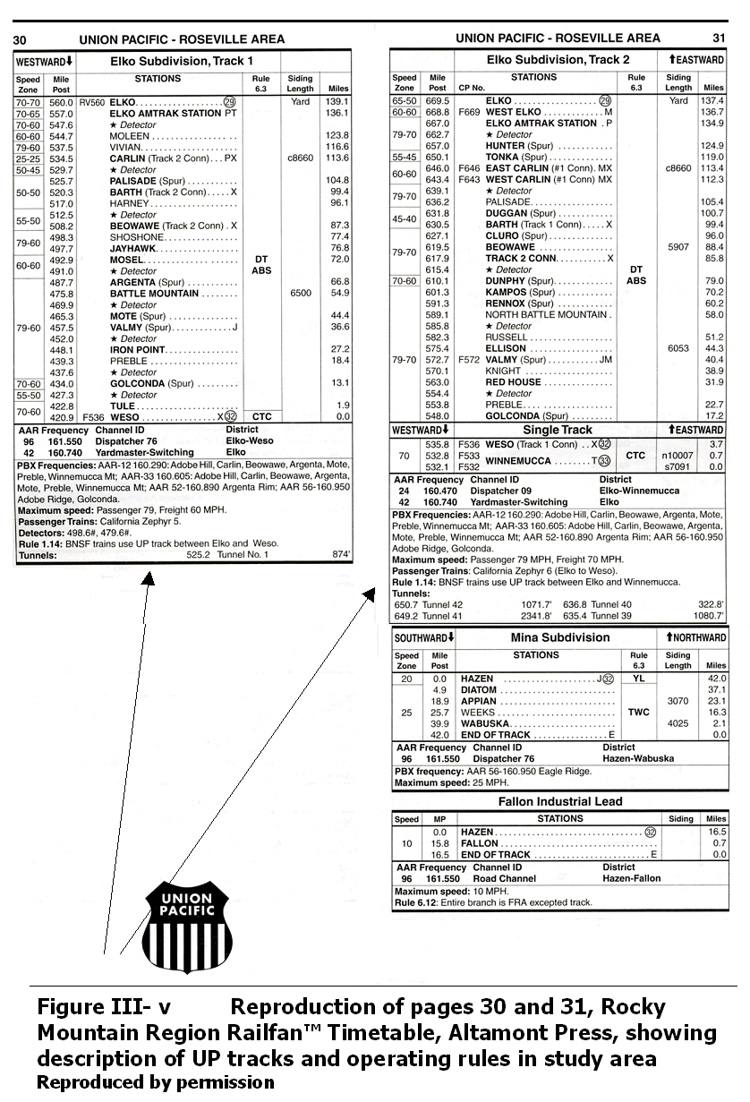
Table of Contents

   Report Cover

   Acknowledgments

I. Executive Summary

II. Introduction

III. Union Pacific Railroad Corridor
A. Introduction and Background
B. Accident Data
C. Weather Effects
D. Current and Historical Train Frequency
E. Physical Features
F. Operations and Regulatory Structure
G. Summary and Conclusion

IV. U.S. Highway 50, State Route 278, and Interstate Highway 80 Corridors
A. Introduction
B. Project Limits
C. Roadway Terrain and Passing Zones
D. Route Features
E. NDOT Roadway Class and Traffic Review
F. Speed Data
G. Adjacent Utilities
H. Accident Data
I. Weather/Other Effects
J. Carlin Area Interchanges
K. Conclusion

List of Exhibits, Figures, and Tables

Exhibits

1.    Location Map and Map Index — 100KB
2 a. Union Pacific Corridor west — 100KB
2 b. Union Pacific Corridor east — 120KB
3 a. Interstate 80 Corridor west — 135KB
3 b. Interstate 80 Corridor east — 125KB
4.   State Route 278 Corridor north — 170KB
5.   State Route 278 Corridor central — 175KB
6.   State Route 278 Corridor south — 120KB
7.   U.S. Highway 50 Corridor —180KB
8.   Carlin Interchange Configuration

Figures

III-a Union Pacific Operations in Nevada
III-b Union Pacific Nevada Northern Routes
III-c Photograph of 2005 Carlin Derailment
III-d Eureka County and Vicinity Railroad Accidents per Year, 1975-2005
III-e Causes of Railroad Accidents In or Near Eureka County
III-f Eureka County and Vicinity Railroad Accidents: Type of Accident
III-g Eureka County and Vicinity Railroad Accidents: Type of Track on Which Accident Occurred
III-h Eureka County and Vicinity Railroad Accidents: Type of Equipment Involved
III-i Eureka County and Vicinity Railroad Accidents: Speed at Time of Accident Occurance
III-j Freight Train/Chemical Truck Collision near Beowawe
III-k Union Pacific Tracks in Palisade Canyon, May, 2005
III-l Humboldt River Annual Flows at Palisade
III-m Union Pacific Track near Humboldt River, May, 2005
III-n Union Pacific Track near Humboldt River, May, 2005
III-o Historical Trend of Rail Traffic, Carlin to Alazon, 1970-1990
III-p Billions of Ton Miles, Western U.S. Railroads, 1984-1999
III-q Photograph of Union Pacific Track "Flyover"
III-r Key to Profile Drawings
III-s Profiles of Union Pacific Central Corridor Route through Eureka County
III-t Profiles of Union Pacific Overland Route through Eureka County
III-u Photograph of Track, Tunnels, Humboldt River
III-v Rocky Mountain Region Railfan Timetable description of UP tracks — operating rules
III-w Photograph of Dunphy area
III-x Photograph of Rail Bridges near Palisade
III-y Allowable Gross Weight on Union Pacific Tracks in Eureka County

IV-a Study Area - Project Limits
IV-b Typical Eureka County Road Terrain: US 50 at Kobeh Valley/Lone Mountain west of Eureka
IV-c Typical Drainage: US 50 near Lander/Eureka County Line
IV-d Typical Drainage: US 50 west of Devil's Gate
IV-e Emigrant Pass/I-80 Chain-up/Brake check area
IV-f Rest stop on US 50, 30 miles west of Eureka
IV-g Deficient Bridges: Dunphy Area Looking South at I-80
IV-h NDOT Functional Classification
IV-i NDOT Traffic Count Stations on I-80 (Eureka County)
IV-j Historical Traffic on I-80
IV-k NDOT Traffic Count Stations (Eureka County)
IV-l Historical Traffic on SR 278
IV-m Historical Traffic on US 50
IV-n NDOT Speed Monitoring Locations
IV-o Number and percent of Crashes per County
IV-p Stuck Semi Truck

Tables

III - a Eureka County and Vicinity Railroad Accidents, Track and Equipment Damage, Injuries
III - b Eureka County and Vicinity Railroad Accidents: Accidents Involving Hazardous Materials
III - c Railroad Accident Rate Calculations
III - d Railroad Inspections in Nevada, 2004

IV - a Eureka County Bridge Deficiency List
IV - b Historical Annual Average Daily Traffic on I-80
IV - c Historical Annual Average Daily Traffic on SR 278
IV - d Historical Annual Average Daily Traffic on US 50
IV - e Annual Speed Monitoring Program Stations
IV - f NDOT Right-of-way Permits in Eureka County
IV - g Number and Percent of Crashes by County
IV - h Top Five Primary Crash Types by Severity-Eureka County 2002
IV - i Eureka County Three-Year Accident Data October 2000 through October 2003
IV - j Eureka County Ten-Year Accident Data January 1994 through July 2005
IV - k Eureka County Ten-Year Accident Data Accident rates January 1994 through July, 2005
IV - l Eureka County Accidents on I-80 January 1994 - July 2005
IV - m Eureka County Ten-Year Work Zone Accident Data January 1994 through July 2005

List Of Appendices

A. References, annotated

B. Rail accidents/incidents in study area, detailed tables:

  • Railroad Accidents in Eureka County, 1975-2005
  • Railroad Accidents in Lander County Between Battle Mountain and the Eureka County Line, 1975 - 2005
  • Railroad accidents in Elko County Between Maggie Creek and the Eureka County Line, 1975-2005
  • Highway/Rail Crossing Incidents in Eureka County, 1975-2005

C. Photographs of May, 2005 Carlin derailment
D. Wildland Fires Caused by Railroad Operations

E. Photographs of May, 2005 Humboldt River high water

F. American Association of Railroads Circular No. OT-55-G: Recommended railroad operating procedures for the transportation of hazardous waste

G. Department of Energy July, 2005 policy statement regarding shipment of waste to Yucca Mountain by dedicated trains

H. Response letter from Nevada Senators Ensign and Reid to DOE policy statement regarding shipment of waste by dedicated trains

I. Rail and highway regulations relative to the transportation of radioactive materials and their applicability to states, tribes, shippers, and carriers

J. NDOT Annual Average Daily Traffic: I-80, US-50, SR-278

K. NDOT Annual Speed Monitoring Program
L. NDOT Encroachment Permits: I-80, US-50, SR-278

M. NDOT Accident Data: I-80, US-50, SR-278


Print This Report