The photos below were obtained from public sources.They are being made availible to foster a better understanding of the issues and concerns surrounding the proposed High-Level Waste repository at Yucca Mountain, Nevada. When availible, the source of each photos is indicated. (Click on camera icons to see photos)
2004
![]() (Size 149KB) This is a view inside Yucca Mountain.
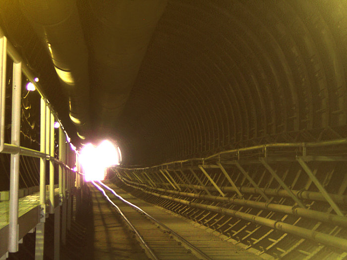
(Size 149KB) This is a view inside Yucca Mountain. 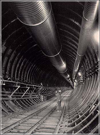 The view is looking down the main tunnel shaft which descends over 5 miles into Yucca Mountain. Click here for another angle (83KB)
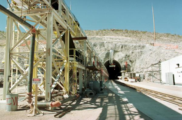
![]() (Size 60KB) View of the tunnel's entrance at Yucca Mountain.
(Size 60KB) View of the tunnel's entrance at Yucca Mountain.
![]() (Size 146KB) View of south portal main tunnel exit.
(Size 146KB) View of south portal main tunnel exit.
2000
![]() (Size 18KB) This is a full view of Yucca Mountain. The point of direction is from the northeast to the southwest toward Amagosa and the Pahurmp Valley. The site occupies lands controlled by the U.S. Department of Energy, the U.S. Air Force (Nellis Range), and the Bureau of Land Management.
(Size 18KB) This is a full view of Yucca Mountain. The point of direction is from the northeast to the southwest toward Amagosa and the Pahurmp Valley. The site occupies lands controlled by the U.S. Department of Energy, the U.S. Air Force (Nellis Range), and the Bureau of Land Management.
![]() (Size 52KB) Workers ride a train down a tunnel inside Yucca Mountain in May.
The Yucca Mountain repository will cost an estimated $43.6 billion before it is completed in 2116, according to DOE budget documents -- Photo by Steve Marcus Las Vegas Sun 01/02/2000
(Size 52KB) Workers ride a train down a tunnel inside Yucca Mountain in May.
The Yucca Mountain repository will cost an estimated $43.6 billion before it is completed in 2116, according to DOE budget documents -- Photo by Steve Marcus Las Vegas Sun 01/02/2000
![]() (Size 37KB) Corbin Harney, spiritual leader for the Western Shoshone, stands in front of a mock-up of a nuclear waste cask at the Sawyer State Office Building before a hearing on the draft environmental impact statement for a proposed Yucca Mountain nuclear waste repository -- Photo by Steve Marcus, Las Vegas Sun 01/12/2000
(Size 37KB) Corbin Harney, spiritual leader for the Western Shoshone, stands in front of a mock-up of a nuclear waste cask at the Sawyer State Office Building before a hearing on the draft environmental impact statement for a proposed Yucca Mountain nuclear waste repository -- Photo by Steve Marcus, Las Vegas Sun 01/12/2000
![]() (Size 37KB) President Clinton vetoes legislation as expected that would have cleared the way for thousands of tons of highly radioactive nuclear waste to be shipped to Yucca Mountain. Nevada Democratic Sens. Harry Reid, left, and Richard Bryan look on with Rep. Shelley Berkley, D-Nev. Associated Press 04/06/2000
(Size 37KB) President Clinton vetoes legislation as expected that would have cleared the way for thousands of tons of highly radioactive nuclear waste to be shipped to Yucca Mountain. Nevada Democratic Sens. Harry Reid, left, and Richard Bryan look on with Rep. Shelley Berkley, D-Nev. Associated Press 04/06/2000
![]() (Size 65KB) Las Vegas Mayor Oscar Goodman, seen here sitting at a control panel at Yucca Mountain in January, has been a vocal opponent of a planned nuclear dump site -- Published in the Las Vegas Sun, Courtesy Photo 06/02/2000.
(Size 65KB) Las Vegas Mayor Oscar Goodman, seen here sitting at a control panel at Yucca Mountain in January, has been a vocal opponent of a planned nuclear dump site -- Published in the Las Vegas Sun, Courtesy Photo 06/02/2000.
1999
![]() (Size 59KB) View from inside Yucca Mountain -- Each week, scientists inside Yucca Mountain download information onto lap top computers from instruments installed in the steel sets in the tunnel. The data is gathered to assess whether the tunnel is expanding or contracting.
(Size 59KB) View from inside Yucca Mountain -- Each week, scientists inside Yucca Mountain download information onto lap top computers from instruments installed in the steel sets in the tunnel. The data is gathered to assess whether the tunnel is expanding or contracting.
![]() (Size 85KB) Workers ride a train inside Yucca Mountain -- Steve Marcus, Las Vegas Sun, 06/02/99
(Size 85KB) Workers ride a train inside Yucca Mountain -- Steve Marcus, Las Vegas Sun, 06/02/99
1998
![]() (Size 53KB) The north portal of Yucca Mountain. Yucca Mountain is located 70 miles northwest of Las Vegas -- Photo by Steve Marcus, Las Vegas Sun 3/27/98
(Size 53KB) The north portal of Yucca Mountain. Yucca Mountain is located 70 miles northwest of Las Vegas -- Photo by Steve Marcus, Las Vegas Sun 3/27/98
![]() (Size 49KB) Touting itself as the Gateway to Death Valley, Beatty is 10 miles west of Yucca Mountain -- by Aaron Mayes Las Vegas Sun 06/01/98.
(Size 49KB) Touting itself as the Gateway to Death Valley, Beatty is 10 miles west of Yucca Mountain -- by Aaron Mayes Las Vegas Sun 06/01/98.
![]() (Size 40KB) Workers stand by an electronic board that keeps track of power delivery, temperature, and costs involved with tests inside the underground laboratory. Department of Energy scientists are conducting an eight-year heating and cooling test on the rock to determine how the heat generated by the buried waste would impact water in the rock -- By Steve Marcus, Las Vegas Sun, 06/02/98
(Size 40KB) Workers stand by an electronic board that keeps track of power delivery, temperature, and costs involved with tests inside the underground laboratory. Department of Energy scientists are conducting an eight-year heating and cooling test on the rock to determine how the heat generated by the buried waste would impact water in the rock -- By Steve Marcus, Las Vegas Sun, 06/02/98
![]() (Size 40KB) In 1998 the U.S. Department of Energy (DOE) initiated one of three planned shipments of foreign research reactor spent nuclear fuel from the Concord Naval shipping yard located near San Francisco to DOE's Idaho Engineering Laboratory in easter Idaho. The fuel was off-loaded and "railed" through California and Nevada.
View thumbnail photo - (Size 23 KB, width 200 pixles)
(Size 40KB) In 1998 the U.S. Department of Energy (DOE) initiated one of three planned shipments of foreign research reactor spent nuclear fuel from the Concord Naval shipping yard located near San Francisco to DOE's Idaho Engineering Laboratory in easter Idaho. The fuel was off-loaded and "railed" through California and Nevada.
View thumbnail photo - (Size 23 KB, width 200 pixles)![]()
1996
![]() (Size 45KB) Nelson O'Connor,a construction engineer for Fluor Daniels Inc., takes a visitor on a tour of the tunnel at Yucca Mountain where they are boring a 5-mile hole near Beatty, Nev. The U.S. government is planning to create the world's first high-level radioactive waste dump at the site. Associated Press
(Size 45KB) Nelson O'Connor,a construction engineer for Fluor Daniels Inc., takes a visitor on a tour of the tunnel at Yucca Mountain where they are boring a 5-mile hole near Beatty, Nev. The U.S. government is planning to create the world's first high-level radioactive waste dump at the site. Associated Press
![]() (Size 72KB)
This is a picture taken from the top of Yucca
(Size 72KB)
This is a picture taken from the top of Yucca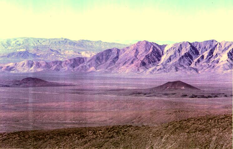 Mountain looking west toward California. In the foreground are two volcanic cinder cones. The photo was taken from the top of Yucca Mountain by a State researcher.
![]() (Size 64KB) This is picture of Crater Flat on the edge of the Nevada Test Site (NTS). This photo was taken from the top of Yucca Mountain by a State researcher. The direction of view is to the northeast looking from the top of Yucca Mountain into the NTS.
(Size 64KB) This is picture of Crater Flat on the edge of the Nevada Test Site (NTS). This photo was taken from the top of Yucca Mountain by a State researcher. The direction of view is to the northeast looking from the top of Yucca Mountain into the NTS.
![]() (Size 160KB) This is an aerial photo of the Exploratory Studies Facility (ESF) at Yucca Mountain. The ESF is actually the tunnel entrance to the first 5 mile tunnel loop in Yucca Mountain. The photo was taken in August 1994 as part of the aerial mapping of the Nevada Test Site (NTS). View thumbnail photo - (Size 16 KB, width 200 pixles)
(Size 160KB) This is an aerial photo of the Exploratory Studies Facility (ESF) at Yucca Mountain. The ESF is actually the tunnel entrance to the first 5 mile tunnel loop in Yucca Mountain. The photo was taken in August 1994 as part of the aerial mapping of the Nevada Test Site (NTS). View thumbnail photo - (Size 16 KB, width 200 pixles)![]()
![]() (Size 125KB) This is an aerial photo of the U.S. Department of Energy's Area 5 Low-Level Waste (LLW) disposal facility. The site is located on the Nevada Test Site (NTS) in Frenchmen Flat. Yucca Mountain is located about 15 miles due west of the site. DOE has disposed of millions of cubic feet of LLW at the Area 5 facility.
(Size 125KB) This is an aerial photo of the U.S. Department of Energy's Area 5 Low-Level Waste (LLW) disposal facility. The site is located on the Nevada Test Site (NTS) in Frenchmen Flat. Yucca Mountain is located about 15 miles due west of the site. DOE has disposed of millions of cubic feet of LLW at the Area 5 facility.
![]() View thumbnail photo - (Size 16 KB, width 200 pixles)
View thumbnail photo - (Size 16 KB, width 200 pixles)
![]() (Size 94KB) This above ground atmospheric nuclear
(Size 94KB) This above ground atmospheric nuclear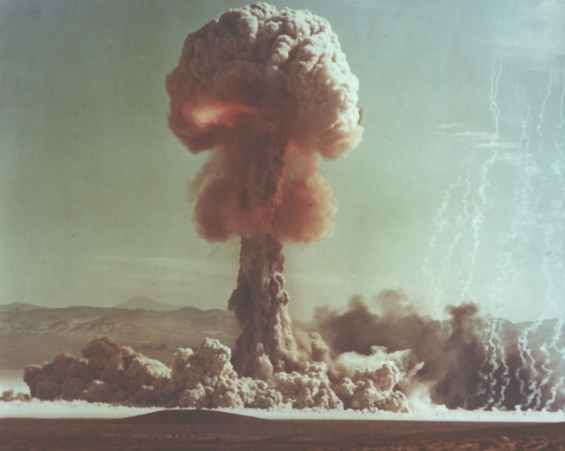 test was conducted at the Nevada Test Site on May 25, 1953. Named "Grable," the nuclear bomb was fired from a 280 mm gun. The test was an Airburst, it was weapons related and had an estimated yield range of 15 Kilotons.
![]() (Size 95KB) View of an above ground atmospheric nuclear test conducted at the Nevada Test Site on August 7, 1957. The tests was called Stokes and was conducted as part the operation "Plumbbob" testing events. Stokes was a 19 kiloton device exploded from a balloon. View thumbnail photo - (Size 9 KB, width 200 pixles)
(Size 95KB) View of an above ground atmospheric nuclear test conducted at the Nevada Test Site on August 7, 1957. The tests was called Stokes and was conducted as part the operation "Plumbbob" testing events. Stokes was a 19 kiloton device exploded from a balloon. View thumbnail photo - (Size 9 KB, width 200 pixles)![]()
![]() (Size 40KB) View of atmosphere atomic test from Las Vegas, Nevada. Above ground testing was conducted between 1951 and 1962. Date of this test is unknown.
(Size 40KB) View of atmosphere atomic test from Las Vegas, Nevada. Above ground testing was conducted between 1951 and 1962. Date of this test is unknown.