2. Description of Geology
 2.1 Physiography 2.1 Physiography
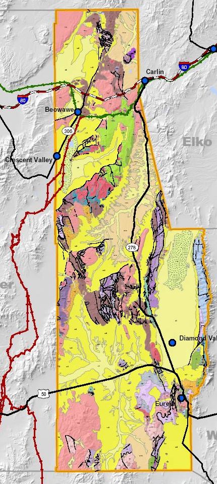
Eureka County is in the Basin and Range Physiographic Province. The ranges and basins were created by extensional forces that resulted in horst and graben structures. These large tilted fault blocks characterize the Basin and Range Physiographic Province.
Topography within Eureka County is comprised of north-south-trending mountain ranges typically 5-15 miles wide and intervening broad, alluvium-filled valleys or basins from 10 to 20 miles wide. The highest point in the county is Summit Mountain at 10,400 feet in the southern portion of the county, while the lowest point in the county is on the Humboldt River in the northwestern portion of the county .The Humboldt River drains the northern portion of the county and the southern portion drains into Diamond Valley.
The major mountain ranges within the county are Sulfur Spring, Roberts, and Cortez. Other major mountain ranges that are partly within the county are Tuscarora, Shoshone, Diamond, Simpson Park, Antelope, Monitor, and Fish Creek. These are generally north-to-northeast trending ranges with faults on either side of the range.
2.2 General Geologic History and Setting
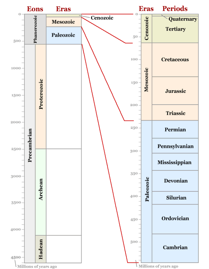
The geology of Eureka County represents a complex history of Paleozoic marine, and Mesozoic marine and non-marine sedimentary deposition in marginal continental accretionary, offshore marine basin settings. The deposition of these sediments was interspersed with periods of folding and thrust faulting as well as contemporaneous intrusive and extrusive activity. This was followed by Cenozoic and Tertiary crustal extension and the formation of horst and graben structures and large tilted fault-blocks that characterize the Basin and Range Physiography Province. This period of crustal extension was also accompanied by coeval (same age) magmatic and volcanic activity.
During Precambrian time and the early Paleozoic Era, marine sediments and volcanics were deposited in an accretionary offshore basin setting within the Cordilleran (ancestral Rocky Mountain) geocline. This geocline was an elongated trough that extended north to south in western North America and included the area that is now eastern Nevada. Sedimentation was marked by two periods of alternating clastic and carbonate deposition (Price, 2004).
These Precambrian and Paleozoic units were deformed in a series of tectonic events characterized by regional east-west compression and associated west-to-east imbricate thrust faulting that in general transported more distal offshore marine sedimentary facies and volcanic rocks over more marginal marine clastic units to the east. Several of these thrust faulting episodes occurred during the Paleozoic and are associated with periods of volcanism and the emplacement of plutons which are temporally and genetically related to major orogenic events.
By the end of the Paleozoic Era, active volcanoes existed in eastern California and western Nevada and volcanism continued throughout most of the Mesozoic Era. In addition, a number of shallow marine invasions inundated parts of the region during the early Mesozoic Era and marine sedimentary formations alternated and inter-tongue with non-marine deposits derived from erosion of rocks further east in the continental interior.
During this time, a coastal strip up to 400 miles wide was formed by a combination of marine sedimentation and igneous activity, granitic intrusions, and volcanism. The early Mesozoic seas spread inland as far as central Utah and Wyoming but were blocked relatively early (Late Triassic period) by a narrow uplift in central Nevada. During the remainder of the Mesozoic Era, only intermittent sub-aerial deposition took place east of this uplift. West of the uplift, a thick sequence of Mesozoic marine and continental sediments was deposited, interspersed with lava flows, volcanic breccia, and tuff (Price, 2004).
The early Mesozoic Era culminated with the Sonoma Orogeny in the western part of North America. Mountain ranges rose and intense deformation of the older rocks occurred across most of Nevada. Late in the Mesozoic Era, the Pacific coastal region was again downwarped and the sea transgressed across the western portion of the Great Basin (Price, 2004).
During the Cenozoic Era, volcanic rocks and sedimentary deposits accumulated over wide areas of western Nevada. As a result, early in the Cenozoic Era, northwestern Nevada was comprised of a high mountain area with external drainage. During middle to late Cenozoic time, orogenic processes initiated the formation of large-scale block faulting structures that would result in the Basin and Range Physiographic Province. As described above, these structures generally are a sequence of alternating horsts and grabens or tilted fault blocks that trend north south and are reflected in the present-day topography.
In late Cenozoic time, the basins formed by the grabens of the Basin and Range Province were filled with continental deposits and minor predominantly basaltic lava flows.
Thick sequences of sediments eroded from the block faulted mountains accumulated in these basins, which were intermittently inundated by lakes. Volcanoes formed throughout the northern Nevada and frequently erupted flows of volcanic ash and lava. Today, much of the northeastern part of the state is covered with these volcanic rocks (Price, 2004).
The Sierra Nevada Mountains of California rose during the Tertiary, creating a rain shadow and arid desert conditions to the east in Nevada. During the Pleistocene, glaciers sculpted the highest peaks of the mountain ranges across Nevada, and tectonic processes continued the formation of Basin and Range physiography. Valleys continued to grow wider and fill with sediment. Volcanic eruptions continued throughout the state, depositing ash flows and lava (Nevada Paleontology, 2004). Quaternary deposits are present in many of the basin fill areas of Eureka County and consist predominantly of poorly consolidated to unconsolidated alluvial and lacustrine sediments.
The diverse and complex geology and geologic history of Eureka County is the basis for the genesis of the abundant mineral resources. The Mineral Resource Occurrence section provides description of the geology associated with each resource.
|