Social Indicators
 OVERVIEW
Located in northeastern Nevada, Eureka County was established in 1873. The county covers 4,182 square miles.
Geography is typical basin and range topography, with long, mostly north-south trending, alluvium-filled valleys separated by mountain ranges. Elevations range from a high of around 10,461 feet at the Summit Mountains in the Monitor Range to about 4,000 feet elevation on the floors of several of the lower basins.
Principal communities are the county seat, Eureka, in the southern end of the county and the towns of Crescent Valley and Beowawe in the north. The Humboldt River winds through the northern part of the county. This is a major transportation corridor both historically and in the present.
Thousands traveled the emigrant trail along the Humboldt River in the nineteenth century; now the corridor holds Interstate Highway 80, as well as Union Pacific railroad tracks. U.S. Highway 50 provides access to the southern end of the county and to the county seat.
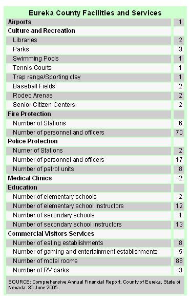
Eureka County towns are relatively isolated, but County and City governments, as well as private businesses, provide a range of services to residents and visitors, as listed in the table to the right.
VOTING
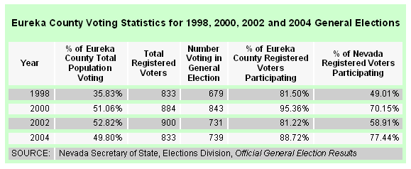
As the table and the line graph belwo show, voter turnout in Eureka County is very high. Voter turnout in the last four general elections averaged 86.7%, while in Nevada as a whole the percentage of registered voters who voted averaged only 64%.

PUBLIC SAFETY
The State of Nevada created a uniform crime reporting program in 1991. The Department of Public Safety obtains crime figures from local jurisdictions in Nevada and publishes them in an annual report, Crime and Justice in Nevada.
During 2005 only 18 "index" crimes were reported in Eureka County. This gives Eureka County a crime rate of 12.12 per thousand population, just over one quarter of the crime rate for the state as a whole of 46.04.
 Traffic crashes
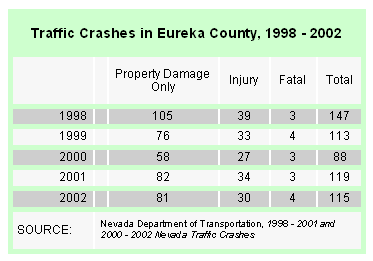
Traffic crashes in Eureka County in 2002 totaled 115, with four fatal crashes. According to the Nevada Department of Transportation 2002 Nevada Traffic Crashes the top three contributing factors to traffic crashes in Eureka County were were "speed too fast for conditions," "animal in roadway (deer)" and "inattentive driving."
This is consistent with the causative factors in other rural Nevada counties. Of the four fatal crashes in Eureka County in 2002, two took place on Interstate 80; one took place on U.S. Highway 50; and one took place on State Route 278. Between 1998 and 2001 all fatal crashes took place either on Interstate Highway 80 or on U.S. Highway 50.
In 2002 Eureka County had 0.18% of the statewide total crashes. With a crash rate of 106.24 per 100,000,000 vehicle miles, Eureka County has the fifth lowest crash rate in Nevada counties, behind Esmeralda, Humboldt, Mineral and Pershing Counties. The overall Nevada statewide crash rate is 323.82.
|


