

ACCIDENT DATA - continued
C WEATHER EFFECTS
Extreme Heat and Cold
A 1991 statistical study of the 1984-1988 rail accident data nationwide (Lee, 1991) found that adverse weather conditions accounted for only 11.4% of accidents, with most (64%) accidents taking place in clear weather conditions. The study performed a statistical analysis of the data to determine whether daily accident rates were affected by any of the environmental risk factors in the database, including weather, temperature and visibility, in order to predict accidents based on the presence of these factors. The conclusion was that "if the analysis is restricted to these variables, accident prediction would be completely random." In other words, these environmental factors appeared to have no effect on the accident rate.
The study did find a relationship between extreme hot and cold weather and the amount of damage in a rail accident: specifically, at temperatures 0-10 degrees and over 100 degrees Fahrenheit, the mean percentage of cars damaged or derailed in accidents was up to 6% higher than in more moderate temperatures. The author of this study cautions (Saricks, pers. com.) however, "against applying paradigms developed from 1980's rail accident data and statistics to current conditions. Overall, quality of track is today much improved over what the general case was twenty years ago, so the entire issue of derailments and their relationships to temperature extremes needs to be re-examined."
Regarding this identified relationship between temperature extremes and derailment damage, the study concludes, "...a higher than usual degree of caution may be warranted in consigning [hazardous waste] shipments if ambient temperatures en route are expected to be either extremely high or extremely low." Again, however, this conclusion may no longer hold in light of recent rail improvements.
Weather records from Rand Ranch, Palisade, Nevada, from the period 1956-1981, show January and December average minimum temperatures of 9.3 and 9.9 degrees Fahrenheit, and average maximum temperatures in July and August of 88.8 and 86.3 degrees Fahrenheit. If there still exists some correlation between extreme temperature conditions and derailment accident damage, such conditions exist in the study area only at the low temperature extreme in the months of December and January, and not at the higher extreme.
Nevada Public Utilities Commission (PUCN) rail inspectors are aware of the potential effects of extreme heat and cold, as well as extreme daily temperature fluctuations on the condition of track, and they schedule track inspections in areas of the State, and at times when such extremes are likely to occur. Likewise, Union Pacific schedules its own inspections during extreme temperature periods (Steele, pers com.)
Delays Due to Storms
 Events in 2005 show that weather can cause delays in rail movement. Union Pacific Corporation's 2004 Annual Report states that the January west coast storm in the Los Angeles Basin, Nevada and Utah, "severely limited...operations in that region for several weeks."
Flooding
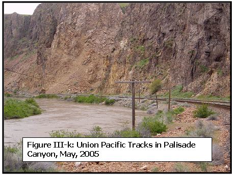
In Eureka County, the two Union Pacific tracks run through Palisade Canyon along the Humboldt River. The tracks cross the river in numerous places. In some places both tracks are on one side of the river, in others, the tracks are on both sides.
The tracks are often very close to the river; sometimes between the river and a cliff. (See photograph on right)
The Humboldt River watershed covers 16,840 square miles of northeastern Nevada, including portions of Elko, Eureka, Lander, Humboldt, Pershing, White Pine, Nye, and Churchill Counties. From its headwaters in the Jarbidge, Independence and Ruby Mountains in Elko County, the river flows approximately 310 miles to its terminus in the Humboldt Sink in the desert of northwest Churchill County.
The upper Humboldt drainage basin, defined by researchers as the drainage area upstream from a USGS stream gauge at Palisade, Nevada, covers approximately 5,040 square miles. The source of Humboldt River flow is typically in the form of snowpack runoff from upper elevation watersheds, primarily those in the Ruby Mountains, the Jarbidge Mountains and the Independence Mountains.
During normal water years from Palisade downstream the flow in the Humboldt River gradually declines as few of the lower basin's principal tributary streams and drainage areas provide any surface water runoff to the river.
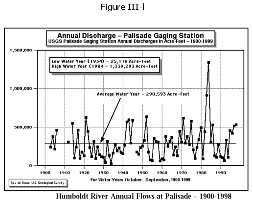
Figure III-k (see photo above) shows annual discharge, in acre feet, in the Humboldt River in most years in the 20th century. As the chart shows, annual discharge in the Humboldt River varies greatly, from a low water year of 25,178 acre feet in 1934, to a high water year of 1,339,293 acre feet in 1984. The river's flow varies greatly throughout the year as well, with 77% of the average year's discharge taking place in the four months of March, April, May, and June (Nevada Division of Water Resources, 2000).
During the 20th century, there were four floods in the upper Humboldt basin of greater than 50-year recurrence intervals * : a 100-year flood in February 1910; a 50-year flood in February 1962; a 50-year flood in April 1983; and a 100-year flood in May 1984. (Paulsen)
* A recurrence interval is the average interval in years between hydrological events equaling or exceeding a given magnitude. A 100-year flood, for example, would be expected to occur on average one time in a hundred years. (Dunne and Leopold)
|